IMAGES TAKEN NEAR TO
Salcombe Regis, SIDMOUTH, EX10 0PD
Introduction
This page details the photographs taken nearby to EX10 0PD by members of the Geograph project.
The Geograph project started in 2005 with the aim of publishing, organising and preserving representative images for every square kilometre of Great Britain, Ireland and the Isle of Man.

There are currently over 7.5m images from over14,400 individuals and you can help contribute to the project by visiting https://www.geograph.org.uk
Image Map
Images are licensed for reuse under creativecommons.org/licenses/by-sa/2.0
Notes
- Clicking on the map will re-center to the selected point.
- The higher the marker number, the further away the image location is from the centre of the postcode.
Image Listing (8 Images Found)
Images are licensed for reuse under creativecommons.org/licenses/by-sa/2.0
Image
Details
Distance
1
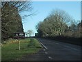
The A3052 passes the King's Down Tail camp site
Image: © Sarah Charlesworth
Taken: 7 Dec 2008
0.09 miles
2
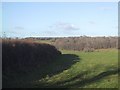
Field Boundary east of Paccombe Hill
Image: © Sarah Charlesworth
Taken: 25 Nov 2008
0.09 miles
3
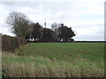
Kingsdown Tail water tower
Across the road from here is the site of one WWII's Chain Home radar installations. A number of the buildings are still in use as a camp site.
The tower served the original site.
Image: © Anthony Vosper
Taken: 28 Nov 2011
0.12 miles
4
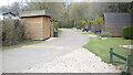
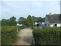
Oakdown Touring Park
Oakdown Touring Park. Taken outside the Shepherd's Huts.
Image: © s
Taken: 15 Apr 2019
0.13 miles
5

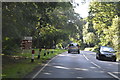
Bus stop and junction sign for Honiton and Branscombe
Image: © Rob Purvis
Taken: 29 Apr 2024
0.14 miles
8

Gatedown Lane
Leading to a number of camp sites.
Image: © Anthony Vosper
Taken: 28 Nov 2011
0.25 miles