IMAGES TAKEN NEAR TO
Greenway Lane, SIDMOUTH, EX10 0LZ
Introduction
This page details the photographs taken nearby to Greenway Lane, EX10 0LZ by members of the Geograph project.
The Geograph project started in 2005 with the aim of publishing, organising and preserving representative images for every square kilometre of Great Britain, Ireland and the Isle of Man.

There are currently over 7.5m images from over14,400 individuals and you can help contribute to the project by visiting https://www.geograph.org.uk
Image Map
Images are licensed for reuse under creativecommons.org/licenses/by-sa/2.0
Notes
- Clicking on the map will re-center to the selected point.
- The higher the marker number, the further away the image location is from the centre of the postcode.
Image Listing (25 Images Found)
Images are licensed for reuse under creativecommons.org/licenses/by-sa/2.0
Image
Details
Distance
1
Not to be taken at speed!
Greenway Lane. A classic example of a hump back bridge. This crosses the now disused railway line.
There is a local belief that this is an old Roman road.
Image: © Anthony Vosper
Taken: 17 Sep 2009
0.05 miles
2
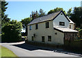
Greenway Gate Toll House by the B3176, Sidmouth
Toll House by the B3176, in parish of Sidmouth (East Devon District), Greenway Cottage, Greenway Lane.
Surveyed
Milestone Society National ID: DV.SID02
Image: © Alan Rosevear
Taken: 3 Jun 2010
0.06 miles
4

Stop and buy some
Stable block and thatched cottage at Stowford Gate.
Two signs offer manure for sale.
Image: © Anthony Vosper
Taken: 2 Oct 2009
0.12 miles
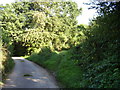
5

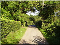
Greenway Lane
A steep hill leading up to Bulverton Hill.
Image: © Richard Webb
Taken: 19 Apr 2011
0.13 miles
6

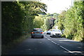
Turn right for Sidmouth
Woolbrook Road, on the line of the old toll road, leaves the A3052 to drop down into Sidmouth
Image: © Richard Law
Taken: 15 Jul 2017
0.14 miles
7
Footpath No.37
This local path starts on the A3052 at Stowford Gate and will take you to Core Hill.
Image: © Anthony Vosper
Taken: 2 Oct 2009
0.15 miles
8

Sidmouth Folkweek Campsite
This is the northern end of one of the fields used for camping by Sidmouth Folkweek.
Image: © Trevor Harris
Taken: 3 Aug 2016
0.15 miles
9
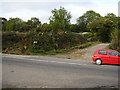
Yet another footpath junction at Bulverton
This is at the top of Greenway Lane and Higher Greenway lane.
Information on the post just visible says 'unmetalled road'. The only vehicles that can use this are tractors. Don't take your mini.
Image: © Anthony Vosper
Taken: 17 Sep 2009
0.16 miles
10
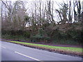
The end of the line, the Bowd lay by
All that remains of the railway bridge in to Sidmouth is covered in ivy.
Image: © Anthony Vosper
Taken: 24 Jan 2011
0.16 miles