IMAGES TAKEN NEAR TO
Orchard Close, SIDMOUTH, EX10 0BB
Introduction
This page details the photographs taken nearby to Orchard Close, EX10 0BB by members of the Geograph project.
The Geograph project started in 2005 with the aim of publishing, organising and preserving representative images for every square kilometre of Great Britain, Ireland and the Isle of Man.

There are currently over 7.5m images from over14,400 individuals and you can help contribute to the project by visiting https://www.geograph.org.uk
Image Map
Images are licensed for reuse under creativecommons.org/licenses/by-sa/2.0
Notes
- Clicking on the map will re-center to the selected point.
- The higher the marker number, the further away the image location is from the centre of the postcode.
Image Listing (32 Images Found)
Images are licensed for reuse under creativecommons.org/licenses/by-sa/2.0
Image
Details
Distance
1
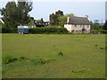
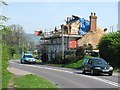
Cottage and pasture, Newton Poppleford
Brook Cottage, which backs onto the stream shown in Image, is "robably C18" http://www.britishlistedbuildings.co.uk/en-352376-brook-cottage-newton-poppleford-and-harp . This view is from the A3052 Exeter Road.
Image: © Derek Harper
Taken: 12 Jun 2006
0.04 miles
2

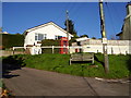
Centre of Burrow
Burrow is an expanded hamlet to the west of Newton Poppleford.
Image: © Jonathan Billinger
Taken: 2 Feb 2010
0.04 miles
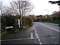
3
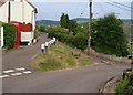
Burrow Corner
You choose,make a telephone call, Post a letter in box No EX10.97 or sit on the bench and watch the world go by.
Image: © Anthony Vosper
Taken: 15 Nov 2010
0.06 miles
4
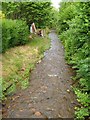
Green, Burrow
This steep little grass triangle also appears in Image
Image: © Derek Harper
Taken: 12 Jun 2006
0.06 miles
5

Post Box No:EX10.97 Burrow Corner
Also in the picture is an OS Bench Mark.
Image: © Anthony Vosper
Taken: 20 Apr 2012
0.06 miles
6

Parsons Farm
On the main A3052 Exeter Road and also shown in http://www.geograph.org.uk/gridref/SY0789?centi=SY077895 . This is the rear of the farmhouse which is described at http://www.britishlistedbuildings.co.uk/en-352377-parsons-farmhouse-newton-poppleford-and- .
Image: © Derek Harper
Taken: 12 Jun 2006
0.07 miles
7
Back Brook
Alternatively refrred to as Poppleford Brook, but mapped as Back Brook. Looking upstream from the lane past Burrow Farm.
Image: © Derek Harper
Taken: 12 Jun 2006
0.07 miles
8
Thatcher at work
Renovating a roof on Exeter Road, Burrow.
Mark Smith, Master Thatcher
01395 578879.
Image: © Richard Webb
Taken: 19 Apr 2011
0.07 miles
10
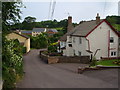
Burrow Farm
The farm and its neighbouring cottage, on the right, are now surrounded by modern housing in this hamlet just outside Newton Poppleford.
Image: © Derek Harper
Taken: 12 Jun 2006
0.08 miles