IMAGES TAKEN NEAR TO
Horseshoe Hill, WALTHAM ABBEY, EN9 3SP
Introduction
This page details the photographs taken nearby to Horseshoe Hill, EN9 3SP by members of the Geograph project.
The Geograph project started in 2005 with the aim of publishing, organising and preserving representative images for every square kilometre of Great Britain, Ireland and the Isle of Man.

There are currently over 7.5m images from over14,400 individuals and you can help contribute to the project by visiting https://www.geograph.org.uk
Image Map (Loading...)


Getting Data...Please wait
Leaflet Map data © OpenStreetMap
Images are licensed for reuse under creativecommons.org/licenses/by-sa/2.0
Notes
- Clicking on the map will re-center to the selected point.
- The higher the marker number, the further away the image location is from the centre of the postcode.
Image Listing (24 Images Found)
Images are licensed for reuse under creativecommons.org/licenses/by-sa/2.0
Image
Details
Distance
1
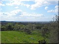
South west view from the garden of the Horseshoes Public House
Image: © Phil Gaskin
Taken: 12 Apr 2011
0.00 miles
2

2nd World War Memorial, St Thomas' Church
The two War Memorials are housed one in each side of the lych gate.
Image: © Lynda Poulter
Taken: 29 Jul 2009
0.03 miles
3

1st World War Memorial
The two war memorials are housed in the lych gate of St. Thomas' Church Upshire.
Image: © Lynda Poulter
Taken: 29 Jul 2009
0.03 miles
4

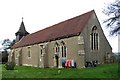
The lych gate, St Thomas' Church, Upshire
Image: © Lynda Poulter
Taken: 29 Jul 2009
0.03 miles