IMAGES TAKEN NEAR TO
Avey Lane, WALTHAM ABBEY, EN9 3QJ
Introduction
This page details the photographs taken nearby to Avey Lane, EN9 3QJ by members of the Geograph project.
The Geograph project started in 2005 with the aim of publishing, organising and preserving representative images for every square kilometre of Great Britain, Ireland and the Isle of Man.

There are currently over 7.5m images from over14,400 individuals and you can help contribute to the project by visiting https://www.geograph.org.uk
Image Map
Images are licensed for reuse under creativecommons.org/licenses/by-sa/2.0
Notes
- Clicking on the map will re-center to the selected point.
- The higher the marker number, the further away the image location is from the centre of the postcode.
Image Listing (9 Images Found)
Images are licensed for reuse under creativecommons.org/licenses/by-sa/2.0
Image
Details
Distance
2
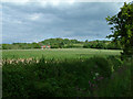
Field by Aveylane Farm
Barley field with hedgerow and road-verge flowers.
Image: © Stephen Dawson
Taken: 17 May 2005
0.04 miles
4
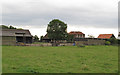
Avey Lane Farm
Seen from public footpath
Image: © Roger Jones
Taken: 13 Jul 2011
0.07 miles
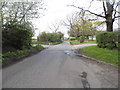
5
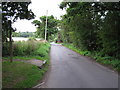
Avey Lane
Near Avey Lane Farm, the post on the far left hand side marks a public footpath entrance
Image: © Roger Jones
Taken: 13 Jul 2011
0.08 miles
6
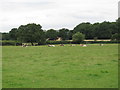
Longhorn cattle at Avey Lane Farm
Seen from public footpath
Image: © Roger Jones
Taken: 13 Jul 2011
0.13 miles
7
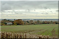
View from Pynest Green Lane
Looking over the Lee Valley.
Image: © Robin Webster
Taken: 17 Nov 2012
0.18 miles
8
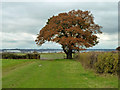
Field corner oak
Near Avey Lane Farm (mapped as Aveylane Farm). A public footpath turns right over the stile.
Image: © Robin Webster
Taken: 17 Nov 2012
0.21 miles
9
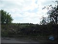
Barricaded gate on Avey Lane
First came the log and then the branches. I don't think they want people to use it.
Image: © David Howard
Taken: 9 Apr 2014
0.24 miles