IMAGES TAKEN NEAR TO
Lucas Court, WALTHAM ABBEY, EN9 3EG
Introduction
This page details the photographs taken nearby to Lucas Court, EN9 3EG by members of the Geograph project.
The Geograph project started in 2005 with the aim of publishing, organising and preserving representative images for every square kilometre of Great Britain, Ireland and the Isle of Man.

There are currently over 7.5m images from over14,400 individuals and you can help contribute to the project by visiting https://www.geograph.org.uk
Image Map
Images are licensed for reuse under creativecommons.org/licenses/by-sa/2.0
Notes
- Clicking on the map will re-center to the selected point.
- The higher the marker number, the further away the image location is from the centre of the postcode.
Image Listing (4 Images Found)
Images are licensed for reuse under creativecommons.org/licenses/by-sa/2.0
Image
Details
Distance
1
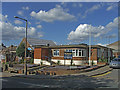
Waltham Abbey Conservative Club, Waltham Abbey, Essex.
Waltham Abbey Conservative Club is situated on the corner of Honey Lane and Rosebank.
Image: © Christine Matthews
Taken: 28 Aug 2006
0.09 miles
2
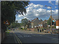
Honey Lane, Waltham Abbey, Essex.
Honey Lane, Waltham Abbey, looking north-west opposite the Conservative Club.
Image: © Christine Matthews
Taken: 28 Aug 2006
0.09 miles
3
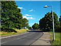
Ninefields, Waltham Abbey
Ninefields is a road throguh a 1970s housing estate in Waltham Abbey.
Image: © Malc McDonald
Taken: 7 Jun 2015
0.22 miles
4
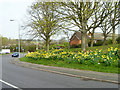
Daffodils by Ninefields
Ninefields is the spine road for a residential area of Waltham Abbey.
Image: © Robin Webster
Taken: 20 Mar 2014
0.23 miles