IMAGES TAKEN NEAR TO
Bumbles Green, WALTHAM ABBEY, EN9 2SD
Introduction
This page details the photographs taken nearby to Bumbles Green, EN9 2SD by members of the Geograph project.
The Geograph project started in 2005 with the aim of publishing, organising and preserving representative images for every square kilometre of Great Britain, Ireland and the Isle of Man.

There are currently over 7.5m images from over14,400 individuals and you can help contribute to the project by visiting https://www.geograph.org.uk
Image Map (Loading...)


Getting Data...Please wait
Leaflet Map data © OpenStreetMap
Images are licensed for reuse under creativecommons.org/licenses/by-sa/2.0
Notes
- Clicking on the map will re-center to the selected point.
- The higher the marker number, the further away the image location is from the centre of the postcode.
Image Listing (24 Images Found)
Images are licensed for reuse under creativecommons.org/licenses/by-sa/2.0
Image
Details
Distance
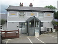
1
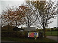
The entrance to Bumble's Green Leisure Centre
Image: © David Howard
Taken: 23 Oct 2015
0.03 miles
4
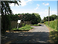
Belchers Lane, Bumbles Green
A dead-end lane. One of the houses on here is humorously named Burp Cottage.
Image: © Stephen Craven
Taken: 23 May 2011
0.11 miles
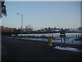
6
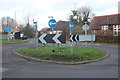
Roundabout on Long Green, Bumble's Green
Image: © David Howard
Taken: 29 Dec 2018
0.11 miles
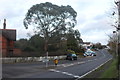
7
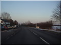
Nazeing Common Road
The King Harold's Head pub is on the left
Image: © David Howard
Taken: 7 Feb 2012
0.11 miles
8
Roundabout on Waltham Road, Bumble's Green
Image: © David Howard
Taken: 23 Oct 2015
0.12 miles
9
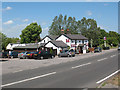
King Harold's Head
A public house on Nazeing Common, named after the king allegedly buried at nearby Waltham Abbey Image
Image: © Stephen Craven
Taken: 23 May 2011
0.12 miles
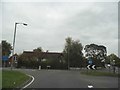
10
Junction of Middle Street and Nazeing Common Road
Image: © David Howard
Taken: 7 Feb 2012
0.12 miles