IMAGES TAKEN NEAR TO
Hoe Lane, WALTHAM ABBEY, EN9 2RL
Introduction
This page details the photographs taken nearby to Hoe Lane, EN9 2RL by members of the Geograph project.
The Geograph project started in 2005 with the aim of publishing, organising and preserving representative images for every square kilometre of Great Britain, Ireland and the Isle of Man.

There are currently over 7.5m images from over14,400 individuals and you can help contribute to the project by visiting https://www.geograph.org.uk
Image Map (Loading...)


Getting Data...Please wait
Leaflet Map data © OpenStreetMap
Images are licensed for reuse under creativecommons.org/licenses/by-sa/2.0
Notes
- Clicking on the map will re-center to the selected point.
- The higher the marker number, the further away the image location is from the centre of the postcode.
Image Listing (3 Images Found)
Images are licensed for reuse under creativecommons.org/licenses/by-sa/2.0
Image
Details
Distance
1
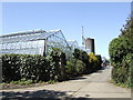
Commercial nursery
On Bumble's Lane between Nazeing and Lower Nazeing. The Lea Valley centred around Roydon-Nazeing is an area of traditional market gardens that were developed in the postwar years to provide salad crops for the London markets thirty miles away. Now the nurseries have diversified into all kinds of horticulture.
Image: © Jonathan Billinger
Taken: 2 May 2007
0.10 miles
2
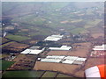
Glasshouses near Nazeing
Part of the Lea Valley glasshouse industry.
Image: © M J Richardson
Taken: 6 Feb 2018
0.22 miles
3
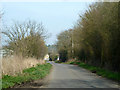
Hoe Lane
A lane with a succession of straights and right-angled bends.
Image: © Robin Webster
Taken: 13 Mar 2014
0.22 miles