IMAGES TAKEN NEAR TO
Long Green, WALTHAM ABBEY, EN9 2LS
Introduction
This page details the photographs taken nearby to Long Green, EN9 2LS by members of the Geograph project.
The Geograph project started in 2005 with the aim of publishing, organising and preserving representative images for every square kilometre of Great Britain, Ireland and the Isle of Man.

There are currently over 7.5m images from over14,400 individuals and you can help contribute to the project by visiting https://www.geograph.org.uk
Image Map (Loading...)


Getting Data...Please wait
Leaflet Map data © OpenStreetMap
Images are licensed for reuse under creativecommons.org/licenses/by-sa/2.0
Notes
- Clicking on the map will re-center to the selected point.
- The higher the marker number, the further away the image location is from the centre of the postcode.
Image Listing (16 Images Found)
Images are licensed for reuse under creativecommons.org/licenses/by-sa/2.0
Image
Details
Distance
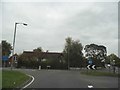
1
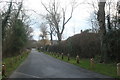
Junction of Middle Street and Nazeing Common Road
Image: © David Howard
Taken: 7 Feb 2012
0.04 miles
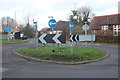
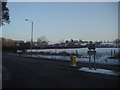
2
Roundabout on Waltham Road, Bumble's Green
Image: © David Howard
Taken: 23 Oct 2015
0.04 miles
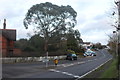
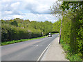
3
Roundabout on Long Green, Bumble's Green
Image: © David Howard
Taken: 29 Dec 2018
0.05 miles
6
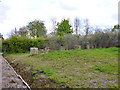
Concrete blocks, Bumble's Green
In the corner of an area of allotments that once was, in this part, a small sewage works. Purpose unknown.
Image: © Robin Webster
Taken: 30 Apr 2016
0.08 miles
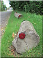
9
Middle Street, Bumble's Green
Heading towards Lower Nazeing.
Image: © Robin Webster
Taken: 30 Apr 2016
0.10 miles