IMAGES TAKEN NEAR TO
Tatsfield Avenue, WALTHAM ABBEY, EN9 2HH
Introduction
This page details the photographs taken nearby to Tatsfield Avenue, EN9 2HH by members of the Geograph project.
The Geograph project started in 2005 with the aim of publishing, organising and preserving representative images for every square kilometre of Great Britain, Ireland and the Isle of Man.

There are currently over 7.5m images from over14,400 individuals and you can help contribute to the project by visiting https://www.geograph.org.uk
Image Map (Loading...)


Getting Data...Please wait
Leaflet Map data © OpenStreetMap
Images are licensed for reuse under creativecommons.org/licenses/by-sa/2.0
Notes
- Clicking on the map will re-center to the selected point.
- The higher the marker number, the further away the image location is from the centre of the postcode.
Image Listing (13 Images Found)
Images are licensed for reuse under creativecommons.org/licenses/by-sa/2.0
Image
Details
Distance
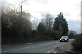
2
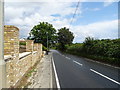
St Leonards Road
The B195 towards Lower Nazeing.
Image: © JThomas
Taken: 20 Jul 2019
0.11 miles
3
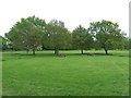
Clayton Hill Country Park, near Nazeing
Clayton Hill Country Park is in the Lea Valley, near the border of Essex and Hertfordshire.
Image: © Malc McDonald
Taken: 1 Jun 2013
0.14 miles
4
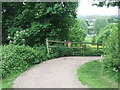
Path near Lower Nazeing, Essex
This path is for use by cyclists as well as walkers. It is part of National Cycle Network route 1, which stretches up the east side of Britain from Dover to the Shetland Islands.
Image: © Malc McDonald
Taken: 1 Jun 2013
0.18 miles
5
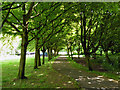
A shady walk, Lower Nazeing
By the car park in the Clayton Hill part of the Lee Valley Park.
Image: © Robin Webster
Taken: 15 May 2016
0.18 miles
6
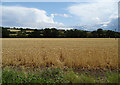
Crop field, Lower Nazeing
Off St Leonards Road.
Image: © JThomas
Taken: 20 Jul 2019
0.20 miles
7
Nazeing Road
This is just in front of the local parade of shops with its own car park.
Image: © David Howard
Taken: 29 Dec 2018
0.22 miles
8
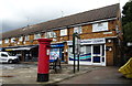
Dentists on Naezing Road, Naezing
Showing position of Postbox No. EN9 70.
See Image] for postbox.
Image: © JThomas
Taken: 20 Jul 2019
0.23 miles
9
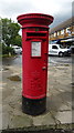
Elizabeth II postbox on Naezing Road, Naezing
Postbox No. EN9 70.
See Image] for context.
Image: © JThomas
Taken: 20 Jul 2019
0.23 miles
10

Lower Nazeing: Nazeingbury Parade
These community shops are on the north side of Nazeing Road. At one time the only settlement in the area was Nazeingbury Manor which occupied a square-shaped area of land extending about 200 metres west and north of the Lower Nazeing crossroads, including the space where these shops are now. The shops themselves are shown on a Francis Frith photograph dated c 1960 https://www.francisfrith.com/nazeing/nazeing-nazeingbury-parade-c1960_n66012
Image: © Nigel Cox
Taken: 14 Jul 2006
0.24 miles