IMAGES TAKEN NEAR TO
Paynes Lane, WALTHAM ABBEY, EN9 2EY
Introduction
This page details the photographs taken nearby to Paynes Lane, EN9 2EY by members of the Geograph project.
The Geograph project started in 2005 with the aim of publishing, organising and preserving representative images for every square kilometre of Great Britain, Ireland and the Isle of Man.

There are currently over 7.5m images from over14,400 individuals and you can help contribute to the project by visiting https://www.geograph.org.uk
Image Map (Loading...)


Getting Data...Please wait
Leaflet Map data © OpenStreetMap
Images are licensed for reuse under creativecommons.org/licenses/by-sa/2.0
Notes
- Clicking on the map will re-center to the selected point.
- The higher the marker number, the further away the image location is from the centre of the postcode.
Image Listing (2 Images Found)
Images are licensed for reuse under creativecommons.org/licenses/by-sa/2.0
Image
Details
Distance
1
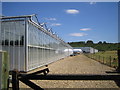
Lower Nazeing: Paynes Lane nurseries
The Lee Valley has long been the home of many nurseries growing vegetables and flowers. Some are disused and derelict now, but this one, which belongs to Valley Grown Nurseries, reflects the amount of investment necessary to operate a modern nursery. The far unit beyond the silver tank has 50 bays, and the overall area under glass is about 10 acres or about 4 hectares. The nursery houses about 220,000 plants. Clayton Hill is visible beyond the far unit.
Image: © Nigel Cox
Taken: 14 Jul 2006
0.14 miles
2
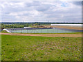
New reservoir
The public footpath formerly went straight ahead here, but has been diverted to the left of this new high level reservoir. Although a sign says the footpath is open, there are no signs indicating exactly where the new route goes yet, with ground works still in progress over what is probably part of the new route.
Image: © Robin Webster
Taken: 15 May 2016
0.25 miles