IMAGES TAKEN NEAR TO
Holyfield, WALTHAM ABBEY, EN9 2EG
Introduction
This page details the photographs taken nearby to Holyfield, EN9 2EG by members of the Geograph project.
The Geograph project started in 2005 with the aim of publishing, organising and preserving representative images for every square kilometre of Great Britain, Ireland and the Isle of Man.

There are currently over 7.5m images from over14,400 individuals and you can help contribute to the project by visiting https://www.geograph.org.uk
Image Map (Loading...)


Getting Data...Please wait
Leaflet Map data © OpenStreetMap
Images are licensed for reuse under creativecommons.org/licenses/by-sa/2.0
Notes
- Clicking on the map will re-center to the selected point.
- The higher the marker number, the further away the image location is from the centre of the postcode.
Image Listing (6 Images Found)
Images are licensed for reuse under creativecommons.org/licenses/by-sa/2.0
Image
Details
Distance
1
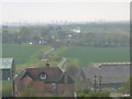
Holyfield Hall Farm
The Lea Valley Tourist Map shows a viewpoint to the north of Hayes Hill Farm at Fishers Green. This view south from the viewpoint has Holyfield Hall Farm in the foreground and, in the distance, the high buildings of the City of London.
Image: © John Reeves
Taken: 24 Apr 2012
0.03 miles
2
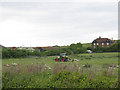
Holyfield Hall Farm
An interpretation board on the farm access track describes this as "a fully commercial dairy, beef and arable unit which allows the public to discover where their food comes from in safe and secure surroundings". It seems to be geared mainly to parties of schoolchildren.
Image: © Stephen Craven
Taken: 23 May 2011
0.04 miles
3
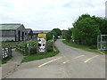
Holyfield Hall Farm, near Waltham Abbey
The entrance to Holyfield Farm in the Lea Valley near Waltham Abbey.
The small blue sign to the left of the cow picture indicates the route of National Cycle Network route 1, which passes here on its way from Dover up the east side of Britain to the Shetland Islands.
Image: © Malc McDonald
Taken: 1 Jun 2013
0.18 miles
4
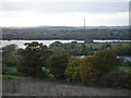
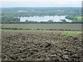
Lee Valley from the top of Colemans Lane.
Taken from the east side of the Lee Valley looking out over the south east corner of Hertfordshire. See also the additional photos for this square.
Image: © Robin Hall
Taken: 13 Nov 2005
0.22 miles
6
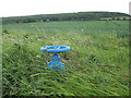
Irrigation valve
There were several such water valves alongside the cycle track through Holyfield Hall Farm. I presume they are for irrigation purposes.
Image: © Stephen Craven
Taken: 23 May 2011
0.23 miles