IMAGES TAKEN NEAR TO
Greenview Grove, WALTHAM ABBEY, EN9 2BS
Introduction
This page details the photographs taken nearby to Greenview Grove, EN9 2BS by members of the Geograph project.
The Geograph project started in 2005 with the aim of publishing, organising and preserving representative images for every square kilometre of Great Britain, Ireland and the Isle of Man.

There are currently over 7.5m images from over14,400 individuals and you can help contribute to the project by visiting https://www.geograph.org.uk
Image Map
Images are licensed for reuse under creativecommons.org/licenses/by-sa/2.0
Notes
- Clicking on the map will re-center to the selected point.
- The higher the marker number, the further away the image location is from the centre of the postcode.
Image Listing (11 Images Found)
Images are licensed for reuse under creativecommons.org/licenses/by-sa/2.0
Image
Details
Distance
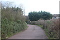
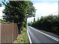
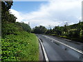
2
Marsh Hill between Nazeing and Waltham Abbey
Image: © David Howard
Taken: 29 Dec 2018
0.09 miles
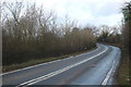
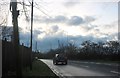
3
Marsh Hill between Nazeing and Waltham Abbey
Image: © David Howard
Taken: 29 Dec 2018
0.10 miles
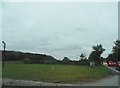
4
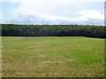
Grassland, Marsh Hill
Towards Galleyhill Wood.
Image: © JThomas
Taken: 20 Jul 2019
0.12 miles
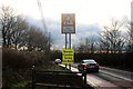
8
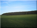
Galleyhill Wood from the road beside Marsh Hill House
Looking over the pleasant green fields to Galleyhill Wood, which covers the top of the hill.
Image: © O O'Brien
Taken: 11 Mar 2007
0.20 miles
10
Marsh Hill between Nazeing and Waltham Abbey
Image: © David Howard
Taken: 29 Dec 2018
0.23 miles