IMAGES TAKEN NEAR TO
Galley Hill, WALTHAM ABBEY, EN9 2AS
Introduction
This page details the photographs taken nearby to Galley Hill, EN9 2AS by members of the Geograph project.
The Geograph project started in 2005 with the aim of publishing, organising and preserving representative images for every square kilometre of Great Britain, Ireland and the Isle of Man.

There are currently over 7.5m images from over14,400 individuals and you can help contribute to the project by visiting https://www.geograph.org.uk
Image Map (Loading...)


Getting Data...Please wait
Leaflet Map data © OpenStreetMap
Images are licensed for reuse under creativecommons.org/licenses/by-sa/2.0
Notes
- Clicking on the map will re-center to the selected point.
- The higher the marker number, the further away the image location is from the centre of the postcode.
Image Listing (6 Images Found)
Images are licensed for reuse under creativecommons.org/licenses/by-sa/2.0
Image
Details
Distance
1
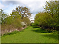
Path towards Breach Barns Farm
Beyond the farmhouse is a large chalet park.
Image: © Robin Webster
Taken: 30 Apr 2016
0.15 miles
2

Paths in Maple Springs
To the right is the public route.
Image: © Robin Webster
Taken: 30 Apr 2016
0.16 miles
3
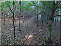
New plantings near Brook Meadow Farm
Interior of a small wood.
Image: © Roger Jones
Taken: 6 Oct 2012
0.17 miles
4
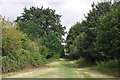
The Path to Breach Barns
The footpath eventually leads to Image
Image: © Glyn Baker
Taken: 23 Jul 2017
0.17 miles

6
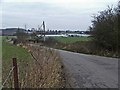
Breach Barns Lane leads from Dallance Farm to Oakwood Nursery
Breach Barns Lane is a small road off Galleyhill Road, leading from Dallance Farm to Oakwood Nursery
Image: © Christine Matthews
Taken: 5 Feb 2006
0.22 miles