IMAGES TAKEN NEAR TO
Galley Hill, WALTHAM ABBEY, EN9 2AQ
Introduction
This page details the photographs taken nearby to Galley Hill, EN9 2AQ by members of the Geograph project.
The Geograph project started in 2005 with the aim of publishing, organising and preserving representative images for every square kilometre of Great Britain, Ireland and the Isle of Man.

There are currently over 7.5m images from over14,400 individuals and you can help contribute to the project by visiting https://www.geograph.org.uk
Image Map (Loading...)


Getting Data...Please wait
Leaflet Map data © OpenStreetMap
Images are licensed for reuse under creativecommons.org/licenses/by-sa/2.0
Notes
- Clicking on the map will re-center to the selected point.
- The higher the marker number, the further away the image location is from the centre of the postcode.
Image Listing (8 Images Found)
Images are licensed for reuse under creativecommons.org/licenses/by-sa/2.0
Image
Details
Distance
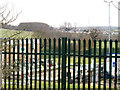
1
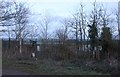
Fence by Epping Booster Station
All the transformers are behind here
Image: © David Howard
Taken: 29 Dec 2018
0.04 miles
2
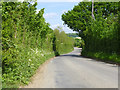
Galley Hill Road
A dead end as a tarmac road, but quite busy as it gives access to many premises.
Image: © Robin Webster
Taken: 15 May 2016
0.09 miles
4
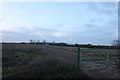
Field by Galley Hill Road, Waltham Abbey
Image: © David Howard
Taken: 29 Dec 2018
0.13 miles
5
Galleyhill gas booster station
The plant is surrounded by a security fence, and I could not get close enough to the fence because of brambles etc. to take a picture through it.
Image: © Stephen Craven
Taken: 15 Mar 2014
0.15 miles
6
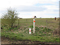
Gas pipeline marker, Galleyhill Road
The marker is opposite the booster station Image
Image: © Stephen Craven
Taken: 15 Mar 2014
0.16 miles
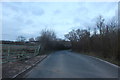
7
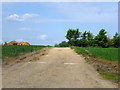
Farm track off Galley Hill Road
A gated private track, with a public footpath crossing at the top of the rise where the yellow marker post is.
Image: © Robin Webster
Taken: 15 May 2016
0.17 miles
8
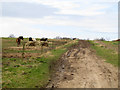
Footpath to Claygate Lane
A view westwards from Galleyhill Road along a farm track that is also a public footpath, past a few feeding horses.
Image: © Stephen Craven
Taken: 15 Mar 2014
0.18 miles