IMAGES TAKEN NEAR TO
Mead Court, WALTHAM ABBEY, EN9 1RG
Introduction
This page details the photographs taken nearby to Mead Court, EN9 1RG by members of the Geograph project.
The Geograph project started in 2005 with the aim of publishing, organising and preserving representative images for every square kilometre of Great Britain, Ireland and the Isle of Man.

There are currently over 7.5m images from over14,400 individuals and you can help contribute to the project by visiting https://www.geograph.org.uk
Image Map
Images are licensed for reuse under creativecommons.org/licenses/by-sa/2.0
Notes
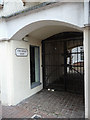
- Clicking on the map will re-center to the selected point.
- The higher the marker number, the further away the image location is from the centre of the postcode.
Image Listing (154 Images Found)
Images are licensed for reuse under creativecommons.org/licenses/by-sa/2.0
Image
Details
Distance
1
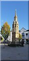
Eleanor Cross, Waltham Cross
This has been cleaned up since I last visited.
Image: © Christine Matthews
Taken: 21 Oct 2021
0.03 miles
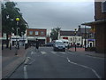
2
Indian restaurant, Waltham Abbey
Former public house ("Coach and Horses") converted to restaurant use.
Image: © Jim Osley
Taken: 19 Jan 2014
0.10 miles
4
Indian restaurant on Greenyard, Waltham Abbey
Image: © JThomas
Taken: 20 Jul 2019
0.13 miles
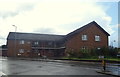
5
King Harold Court, Waltham Abbey, Essex
Waltham Abbey is a small town, which is now on the edge of London. It contains the Waltham Abbey Church and it is said to mark the final resting place of King Harold.
Image: © Christine Matthews
Taken: 16 Jun 2013
0.14 miles
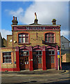
7
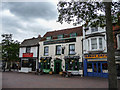
The Green Dragon Public House, Waltham Abbey, Essex
Waltham Abbey is a small town, which is now on the edge of London. It contains the Waltham Abbey Church and it is said to mark the final resting place of King Harold. The Green Dragon is in the square.
Image: © Christine Matthews
Taken: 16 Jun 2013
0.15 miles
8
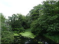
Channel of the Rammey Marsh Flood Relief Channel
View from the bridge on the A121.
Image: © JThomas
Taken: 20 Jul 2019
0.15 miles
9
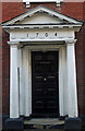
Doric porch, Highbridge Street, Waltham Abbey
Porch to Grade II* listed building, described at this http://list.english-heritage.org.uk/resultsingle.aspx?uid=1337477.
Image: © Jim Osley
Taken: 19 Jan 2014
0.15 miles
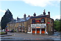
10
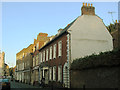
The Old Courthouse, Highbridge Street, Waltham Abbey
This building bears the name "The Old Courthouse" and the date 1704, but the listing (grade 2*, entry 1337477) only identifies it as "31 Highbridge Street" and describes it as an "early to mid 18th century house". So the name may be fanciful.
Image: © Stephen Craven
Taken: 23 Aug 2016
0.15 miles