IMAGES TAKEN NEAR TO
Flagstaff Close, WALTHAM ABBEY, EN9 1JB
Introduction
This page details the photographs taken nearby to Flagstaff Close, EN9 1JB by members of the Geograph project.
The Geograph project started in 2005 with the aim of publishing, organising and preserving representative images for every square kilometre of Great Britain, Ireland and the Isle of Man.

There are currently over 7.5m images from over14,400 individuals and you can help contribute to the project by visiting https://www.geograph.org.uk
Image Map (Loading...)


Getting Data...Please wait
Leaflet Map data © OpenStreetMap
Images are licensed for reuse under creativecommons.org/licenses/by-sa/2.0
Notes
- Clicking on the map will re-center to the selected point.
- The higher the marker number, the further away the image location is from the centre of the postcode.
Image Listing (157 Images Found)
Images are licensed for reuse under creativecommons.org/licenses/by-sa/2.0
Image
Details
Distance
2
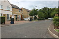
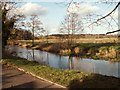
Gate on Flagstaff Road, Waltham Abbey
This leads to the River Lea complex of small and large streams.
Image: © David Howard
Taken: 20 Sep 2022
0.02 miles
3
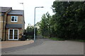
Row of houses on Walton Gardens, Waltham Abbey
Image: © David Howard
Taken: 28 Nov 2021
0.03 miles
4
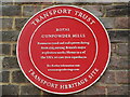
Plaque at Royal Gunpowder Mills
Erected by Transport Trust
Image: © El Loco
Taken: 14 Aug 2022
0.07 miles
5
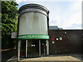
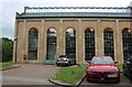
Exhibition Centre at Royal Gunpowder Mills
Shows site of Image
Image: © El Loco
Taken: 14 Aug 2022
0.07 miles
6
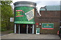
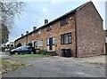
Royal Gunpowder Factory - Exhibition Building
Image: © John M
Taken: 25 Apr 2015
0.08 miles
7
Royal Gunpowder Factory
A tour with Historic England and Council for British Archeology.
Image: © John M
Taken: 25 Apr 2015
0.08 miles
8
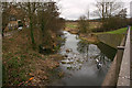
Old River Lea (or Lee), Waltham Abbey
Taken looking upstream from Abbeyview which by-passes the town centre. Waltham Abbey is notable for the number of watercourses flowing through it, all connected by man or nature to the original River Lea (or Lee). Others include the Horsemill Stream, Cornmill Stream and River Lee Navigation.
Image: © David Kemp
Taken: 21 Feb 2017
0.10 miles
10
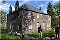
The Power House, Gunpowder Mill
The offices of Hill who appear to have built the fairly new adjacent estate. This used to be the access road to it but it has now been blocked and the only route is up Beaulieu Drive and a new bridge across the flood relief channel.
Image: © David Howard
Taken: 20 Sep 2022
0.10 miles