IMAGES TAKEN NEAR TO
Highbridge Street, WALTHAM ABBEY, EN9 1DZ
Introduction
This page details the photographs taken nearby to Highbridge Street, EN9 1DZ by members of the Geograph project.
The Geograph project started in 2005 with the aim of publishing, organising and preserving representative images for every square kilometre of Great Britain, Ireland and the Isle of Man.

There are currently over 7.5m images from over14,400 individuals and you can help contribute to the project by visiting https://www.geograph.org.uk
Image Map (Loading...)


Getting Data...Please wait
Leaflet Map data © OpenStreetMap
Images are licensed for reuse under creativecommons.org/licenses/by-sa/2.0
Notes
- Clicking on the map will re-center to the selected point.
- The higher the marker number, the further away the image location is from the centre of the postcode.
Image Listing (204 Images Found)
Images are licensed for reuse under creativecommons.org/licenses/by-sa/2.0
Image
Details
Distance
1
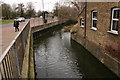
Watercourse which runs beside the Town Hall, Waltham Abbey, Essex.
Watercourse beside the Town Hall in Highbridge Street, Waltham Abbey, Essex.
Image: © Christine Matthews
Taken: 26 Oct 2003
0.01 miles
2
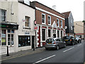
HSBC bank, Highbridge Street
A branch of what used to be the Midland Bank, in Waltham Abbey town centre. A barber shop is also visible in the photo.
Image: © Stephen Craven
Taken: 23 May 2011
0.02 miles
3
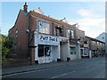
Puff Dad-E, Highbridge Street, Waltham Abbey
An e-cigarette shop, or vaping shop as they are now becoming known.
Image: © Stephen Craven
Taken: 23 Aug 2016
0.02 miles
4
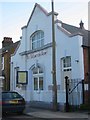
Salvation Army Citadel in Waltham Abbey
This building is rather stark compared with the Abbey photograph but probably is the home of much more lively services complete with brass band.
Image: © Jack Hill
Taken: 9 Aug 2005
0.02 miles
5
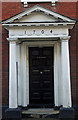
Doric porch, Highbridge Street, Waltham Abbey
Porch to Grade II* listed building, described at this http://list.english-heritage.org.uk/resultsingle.aspx?uid=1337477.
Image: © Jim Osley
Taken: 19 Jan 2014
0.02 miles
6
The Old Courthouse, Highbridge Street, Waltham Abbey
This building bears the name "The Old Courthouse" and the date 1704, but the listing (grade 2*, entry 1337477) only identifies it as "31 Highbridge Street" and describes it as an "early to mid 18th century house". So the name may be fanciful.
Image: © Stephen Craven
Taken: 23 Aug 2016
0.02 miles
7
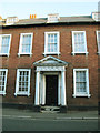
The Old Courthouse (detail)
This building with a pedimented portico bears the name "The Old Courthouse" and the date 1704, but the listing (grade 2*, entry 1337477) only identifies it as "31 Highbridge Street" and describes it as an "early to mid 18th century house". So the name may be fanciful. See Image for a wider context.
Image: © Stephen Craven
Taken: 23 Aug 2016
0.02 miles
8
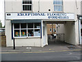
Barge Yard
A courtyard off Highbridge Street, with an unusual name, especially as it is not close to the river. On the street frontage is a business: Exceptional Flooring.
Image: © Stephen Craven
Taken: 23 May 2011
0.03 miles
9
Old River Lea (or Lee), Waltham Abbey
Taken looking upstream from Highbridge Street. Waltham Abbey is notable for the number of watercourses flowing through it, all connected by man or nature to the original River Lea (or Lee). Others include the Horsemill Stream, Cornmill Stream and River Lee Navigation. The main road to the left is Abbeyview which by-passes the town centre.
Image: © David Kemp
Taken: 21 Feb 2017
0.04 miles
10
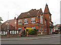
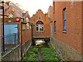
Holy Cross Council offices
Holy Cross was the former name of what is now Epping Forest district council. The building dates from 1904 and is directly opposite Waltham Abbey Church.
Image: © Stephen Craven
Taken: 23 May 2011
0.04 miles