IMAGES TAKEN NEAR TO
Station Road, WALTHAM ABBEY, EN9 1AB
Introduction
This page details the photographs taken nearby to Station Road, EN9 1AB by members of the Geograph project.
The Geograph project started in 2005 with the aim of publishing, organising and preserving representative images for every square kilometre of Great Britain, Ireland and the Isle of Man.

There are currently over 7.5m images from over14,400 individuals and you can help contribute to the project by visiting https://www.geograph.org.uk
Image Map (Loading...)


Getting Data...Please wait
Leaflet Map data © OpenStreetMap
Images are licensed for reuse under creativecommons.org/licenses/by-sa/2.0
Notes
- Clicking on the map will re-center to the selected point.
- The higher the marker number, the further away the image location is from the centre of the postcode.
Image Listing (126 Images Found)
Images are licensed for reuse under creativecommons.org/licenses/by-sa/2.0
Image
Details
Distance
1
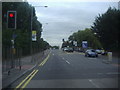
Former Drill Hall - Station Road
Two storey building with hall behind. In 1914 base for H Company, 1st Battalion Hertfordshire Regiment.
Image: © John M
Taken: 25 Apr 2015
0.04 miles
2
PR Pallets on Station Road, Waltham Cross
Image: © David Howard
Taken: 20 Sep 2022
0.04 miles
3
Former Drill Hall - Station Road
Two storey building with hall behind. In 1914 base for H Company, 1st Battalion Hertfordshire Regiment.
Image: © John M
Taken: 25 Apr 2015
0.05 miles
4
Former Drill Hall - Station Road
Two storey building with hall behind. In 1914 base for H Company, 1st Battalion Hertfordshire Regiment.
Image: © John M
Taken: 25 Apr 2015
0.05 miles
6
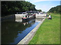
River Lee Navigation: Waltham Town Lock
Narrowboat "Alder" emerges from the downstream end of the lock.
Image: © Nigel Cox
Taken: 27 Aug 2007
0.06 miles
8
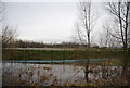
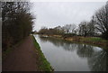
River Lea at Waltham Abbey
The River Lea (or Lee) forms the boundary between the counties of Hertfordshire (on the right bank) and Essex (on the left) here. The towpath is a shared path for walking and cycling.
Image: © Malc McDonald
Taken: 1 Jun 2013
0.09 miles
10
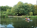
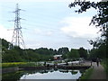
Canoeists on the Lee Navigation
A two-person canoe just above Waltham Town Lock.
Image: © Stephen Craven
Taken: 23 Aug 2016
0.09 miles