IMAGES TAKEN NEAR TO
Windmill Lane, WALTHAM CROSS, EN8 9AN
Introduction
This page details the photographs taken nearby to Windmill Lane, EN8 9AN by members of the Geograph project.
The Geograph project started in 2005 with the aim of publishing, organising and preserving representative images for every square kilometre of Great Britain, Ireland and the Isle of Man.

There are currently over 7.5m images from over14,400 individuals and you can help contribute to the project by visiting https://www.geograph.org.uk
Image Map
Images are licensed for reuse under creativecommons.org/licenses/by-sa/2.0
Notes
- Clicking on the map will re-center to the selected point.
- The higher the marker number, the further away the image location is from the centre of the postcode.
Image Listing (47 Images Found)
Images are licensed for reuse under creativecommons.org/licenses/by-sa/2.0
Image
Details
Distance
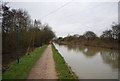
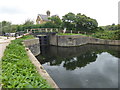
2
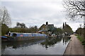
Approaching Waltham Common Lock from the north
A lock on the Lee Navigation near Powdermill Cut.
Image: © Trevor Harris
Taken: 27 Mar 2022
0.01 miles
4
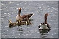
Greylag Geese in Friday Lake
I was having a bit of trouble getting a nice shot of this family until a large Labrador bounced up and caused them to take to the water.
Image: © Glyn Baker
Taken: 23 Apr 2016
0.02 miles
5
Approaching the lock near Powdermill Cut
A lock on the Lee Navigation.
Image: © Trevor Harris
Taken: 10 Mar 2012
0.02 miles
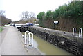
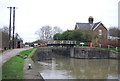
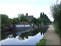
6
Waltham Common Lock
The original River Lea flowed 70 miles from Leagrove Marsh near Luton to the River Thames at Bow Creek. The River Lee Act of 1766 provided for the construction of 15 new cuts to straighten the course of the river by eliminating loops which made it difficult to navigate. This is one of those cuts and hence it is a navigation rather than a river. The Lea passes a little further to the east here. Historically the river is spelled Lea while the navigation is Lee.
This is Waltham Common Lock between Waltham Town Lock and Cheshunt Lock.
Image: © Marathon
Taken: 6 Sep 2017
0.02 miles
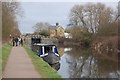
7
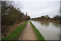
River Lea near Cheshunt
The River Lea (or Lee) near Cheshunt. Here the river forms the boundary between the counties of Hertfordshire (on the right bank) and Essex (on the left). The towpath is a shared path for walking and cycling.
Image: © Malc McDonald
Taken: 1 Jun 2013
0.02 miles