IMAGES TAKEN NEAR TO
Eastfield Road, WALTHAM CROSS, EN8 7EU
Introduction
This page details the photographs taken nearby to Eastfield Road, EN8 7EU by members of the Geograph project.
The Geograph project started in 2005 with the aim of publishing, organising and preserving representative images for every square kilometre of Great Britain, Ireland and the Isle of Man.

There are currently over 7.5m images from over14,400 individuals and you can help contribute to the project by visiting https://www.geograph.org.uk
Image Map
Images are licensed for reuse under creativecommons.org/licenses/by-sa/2.0
Notes
- Clicking on the map will re-center to the selected point.
- The higher the marker number, the further away the image location is from the centre of the postcode.
Image Listing (7 Images Found)
Images are licensed for reuse under creativecommons.org/licenses/by-sa/2.0
Image
Details
Distance
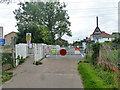
1
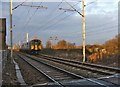
Train approaching Trinity Marsh Lane Level Crossing
Southbound train approaching Trinity Marsh Lane Level Crossing, Cheshunt, Hertfordshire
Image: © Christine Matthews
Taken: 1 Jan 2006
0.05 miles
2
Trinity Marsh Lane level crossing
A public footpath, but the road crossing is for private use only. The railway route is the Bethnal Green to King's Lynn line.
Image: © Robin Webster
Taken: 4 Sep 2015
0.12 miles
3
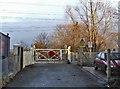
Gates to Trinity Marsh Lane Level Crossing
Gates to Trinity Marsh Lane Level Crossing taken from Trinity Lane, Waltham Cross, looking east
Image: © Christine Matthews
Taken: 1 Jan 2006
0.12 miles
4
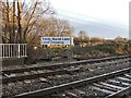
Trinity Marsh Lane Level Crossing
Sign for Trinity Marsh Lane Level Crossing at the end of Trinity Lane, Waltham Cross. This is a foot crossing only
Image: © Christine Matthews
Taken: 1 Jan 2006
0.12 miles