IMAGES TAKEN NEAR TO
Campine Close, WALTHAM CROSS, EN8 0UH
Introduction
This page details the photographs taken nearby to Campine Close, EN8 0UH by members of the Geograph project.
The Geograph project started in 2005 with the aim of publishing, organising and preserving representative images for every square kilometre of Great Britain, Ireland and the Isle of Man.

There are currently over 7.5m images from over14,400 individuals and you can help contribute to the project by visiting https://www.geograph.org.uk
Image Map
Images are licensed for reuse under creativecommons.org/licenses/by-sa/2.0
Notes
- Clicking on the map will re-center to the selected point.
- The higher the marker number, the further away the image location is from the centre of the postcode.
Image Listing (38 Images Found)
Images are licensed for reuse under creativecommons.org/licenses/by-sa/2.0
Image
Details
Distance
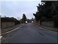
1
Houses on Brookfield Lane West, Turnford
Image: © David Howard
Taken: 28 Nov 2021
0.02 miles
4
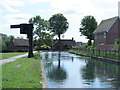
The New River east of Brookfield Lane West, EN8 (2)
Image: © Mike Quinn
Taken: 27 May 2015
0.07 miles
5
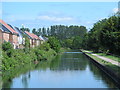
A long, straight stretch of the New River south of Brookfield Lane West, EN8
Image: © Mike Quinn
Taken: 27 May 2015
0.07 miles
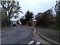
6
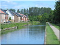
The New River north of Pine Close, EN8
See Image
Image: © Mike Quinn
Taken: 27 May 2015
0.08 miles
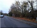
7
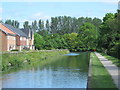
The New River south of Brookfield Lane West, EN8
See Image
Image: © Mike Quinn
Taken: 27 May 2015
0.08 miles
8
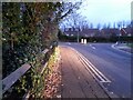
Brookfield Lane West, Turnford
The road is split in two by the A10
Image: © David Howard
Taken: 28 Nov 2021
0.08 miles
9
Field by Brookfield Lane West, Turnford
Image: © David Howard
Taken: 28 Nov 2021
0.08 miles