IMAGES TAKEN NEAR TO
Mylne Close, WALTHAM CROSS, EN8 0PS
Introduction
This page details the photographs taken nearby to Mylne Close, EN8 0PS by members of the Geograph project.
The Geograph project started in 2005 with the aim of publishing, organising and preserving representative images for every square kilometre of Great Britain, Ireland and the Isle of Man.

There are currently over 7.5m images from over14,400 individuals and you can help contribute to the project by visiting https://www.geograph.org.uk
Image Map
Images are licensed for reuse under creativecommons.org/licenses/by-sa/2.0
Notes
- Clicking on the map will re-center to the selected point.
- The higher the marker number, the further away the image location is from the centre of the postcode.
Image Listing (44 Images Found)
Images are licensed for reuse under creativecommons.org/licenses/by-sa/2.0
Image
Details
Distance
1
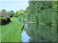
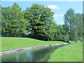
The New River north of Mylne Close, EN8 (2)
Image: © Mike Quinn
Taken: 27 May 2015
0.04 miles
2
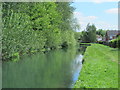
The New River north of Mylne Close, EN8
Image: © Mike Quinn
Taken: 27 May 2015
0.04 miles
3
The New River by Halfhide Lane, EN8 (2)
See Image
Image: © Mike Quinn
Taken: 27 May 2015
0.04 miles
4
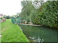
Sluice on New River
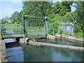
Mapped as a weir, there was insignificant level difference. There are three passages. On the right, a steel plate weir, only operative at higher water levels. In the middle, a sluice, closed in this view. On the left, an unobstructed vaguely venturi section that must be rather deep, as the flow speed was not greatly above that in the full section river, which itself is quite deep.
Image: © Robin Webster
Taken: 4 Sep 2015
0.04 miles
5
Sluice on the New River by Mylne Close, EN8 (2)
See Image
Image: © Mike Quinn
Taken: 27 May 2015
0.04 miles
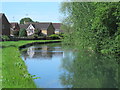
6
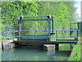
Sluice on the New River by Mylne Close, EN8
See Image
Image: © Mike Quinn
Taken: 27 May 2015
0.04 miles
7
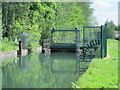
The New River by Mylne Close, EN8
See Image Shows the location of Image
Robert Mylne (1733-1811) was a Scottish architect and engineer; from 1767 until his death he was the Surveyor of the New River Company. he was also the surveyor of St. Paul's Cathedral, catnerbury Cathedral and Greenwich Hospital. For further info, see the Wiki entry https://en.wikipedia.org/wiki/Robert_Mylne_(architect) .
Image: © Mike Quinn
Taken: 27 May 2015
0.04 miles
8
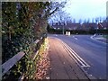
Brookfield Lane West, Turnford
The road is split in two by the A10
Image: © David Howard
Taken: 28 Nov 2021
0.06 miles
9
Field by Brookfield Lane West, Turnford
Image: © David Howard
Taken: 28 Nov 2021
0.06 miles
10
The New River east of Cheshunt Reservoir (North) (2)
See Image
Image: © Mike Quinn
Taken: 27 May 2015
0.06 miles