IMAGES TAKEN NEAR TO
Mill Lane, WALTHAM CROSS, EN8 0JU
Introduction
This page details the photographs taken nearby to Mill Lane, EN8 0JU by members of the Geograph project.
The Geograph project started in 2005 with the aim of publishing, organising and preserving representative images for every square kilometre of Great Britain, Ireland and the Isle of Man.

There are currently over 7.5m images from over14,400 individuals and you can help contribute to the project by visiting https://www.geograph.org.uk
Image Map
Images are licensed for reuse under creativecommons.org/licenses/by-sa/2.0
Notes
- Clicking on the map will re-center to the selected point.
- The higher the marker number, the further away the image location is from the centre of the postcode.
Image Listing (28 Images Found)
Images are licensed for reuse under creativecommons.org/licenses/by-sa/2.0
Image
Details
Distance
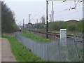
1
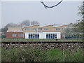
Turnford School, Cheshunt
The newly completed part of Turnford School looking across the playing fields from the Cheshunt to Broxbourne mainline (the rails are big black line across the centre of the photo !)
The rest of the school is to the right of the photo (behind the tree)
Image: © Talisman
Taken: 18 Apr 2008
0.08 miles
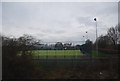
3
Railway line at Turnford Brook
Looking south towards Cheshunt Station Image from the pedestrian bridge adjacent to Turnford Brook where they both cross the Liverpool Street to Cambridge/Ely line.
Turnford Brook is in the fenced culvert at the bottom of the photo. To the left is the Lea Valley Park and to the right is Nightleys a reclaimed gravel pit, turned rubbish tip. Now a playing field.
Image: © Talisman
Taken: 12 Apr 2008
0.16 miles
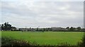
4
Train disturbs the tranquility of Lea Valley Park
13:54 from Broxbourne to London Liverpool Street passing the bridge over the Small River Lea 1km north of Cheshunt Station. The path runs right alongside the railway track until this point, then hops over the bridge to run parallel again.
Image: © Talisman
Taken: 18 Apr 2008
0.16 miles
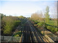
5
Mainline Broxbourne to Cheshunt
Looking south towards Cheshunt Station (abt 1km) just visible to right of centre of the photo is a house alongside the Cadmore Lane Level crossing.
The trees by the radio mast hide a small industrial estate on Fieldings Road. The path on the left runs alongside the railway line to Cheshunt Station.
Image: © Talisman
Taken: 18 Apr 2008
0.17 miles
7
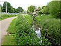
Small River Lee or Lea
Much smaller than the main river. Looking upstream.
Image: © Robin Webster
Taken: 24 May 2016
0.17 miles
8
Bridge over Small River Lea
A glimpse of the bridge shown in Image, from the railway line between Broxbourne and Cheshunt.
Image: © Derek Harper
Taken: 2 Aug 2012
0.18 miles
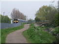
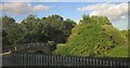
9
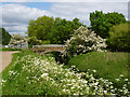
Bridge on Small River Lea or Lee
Formerly used by a continuation of Mill Lane via a level crossing to the left, there is now no crossing, and the bridge is used by a cycle path to switch sides of the river.
Image: © Robin Webster
Taken: 24 May 2016
0.18 miles
10

Bridge over the Small River Lea
...to distinguish it from the main River Lea and the Lee Navigation to the east of here. More immediately to the east is the large lake occupying the North Metropolitan Pit - one of the many former gravel pits in this area.
Image: © Trevor Harris
Taken: 27 Mar 2022
0.18 miles