IMAGES TAKEN NEAR TO
Flamstead End Road, WALTHAM CROSS, EN8 0HJ
Introduction
This page details the photographs taken nearby to Flamstead End Road, EN8 0HJ by members of the Geograph project.
The Geograph project started in 2005 with the aim of publishing, organising and preserving representative images for every square kilometre of Great Britain, Ireland and the Isle of Man.

There are currently over 7.5m images from over14,400 individuals and you can help contribute to the project by visiting https://www.geograph.org.uk
Image Map
Images are licensed for reuse under creativecommons.org/licenses/by-sa/2.0
Notes
- Clicking on the map will re-center to the selected point.
- The higher the marker number, the further away the image location is from the centre of the postcode.
Image Listing (9 Images Found)
Images are licensed for reuse under creativecommons.org/licenses/by-sa/2.0
Image
Details
Distance
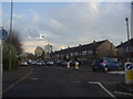
1
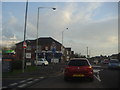
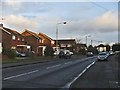
Flamstead End Road at the junction of Church Road
Image: © David Howard
Taken: 12 Apr 2012
0.02 miles
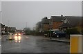
4
Junction of Brookfield Lane West and Flamstead End Road
Image: © David Howard
Taken: 12 Apr 2012
0.21 miles
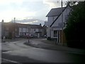
5
Churchgate Road at the junction of Goffs Lane
Image: © David Howard
Taken: 12 Apr 2012
0.22 miles
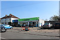
6
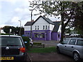
The Box
This building was completely purple until recently but they have toned it down a bit by painting the upper part white.
The Box is a hairdressing salon which sits on the corner of Halfhide Lane and Longfield Lane.
Image: © Talisman
Taken: 1 May 2008
0.22 miles
7
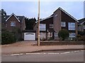
Modern house on Brookfield Road West, Flamstead End
This style was popular in the 70s, I had a flat like it once. https://www.geograph.org.uk/photo/4839443
Image: © David Howard
Taken: 28 Nov 2021
0.22 miles
8
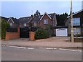
Houses on Brookfield Road West, Flamstead End
Image: © David Howard
Taken: 28 Nov 2021
0.23 miles
9
Longfield Lane, Cheshunt
Longfield Lane, Cheshunt, looking east from the junction with Crown Road.
Image: © Christine Matthews
Taken: 27 Dec 2005
0.25 miles