IMAGES TAKEN NEAR TO
Aldermere Avenue, WALTHAM CROSS, EN8 0FG
Introduction
This page details the photographs taken nearby to Aldermere Avenue, EN8 0FG by members of the Geograph project.
The Geograph project started in 2005 with the aim of publishing, organising and preserving representative images for every square kilometre of Great Britain, Ireland and the Isle of Man.

There are currently over 7.5m images from over14,400 individuals and you can help contribute to the project by visiting https://www.geograph.org.uk
Image Map
Images are licensed for reuse under creativecommons.org/licenses/by-sa/2.0
Notes
- Clicking on the map will re-center to the selected point.
- The higher the marker number, the further away the image location is from the centre of the postcode.
Image Listing (34 Images Found)
Images are licensed for reuse under creativecommons.org/licenses/by-sa/2.0
Image
Details
Distance
1
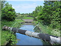
Cheshunt Reservoir South
Water shortage, what water shortage.
This is Cheshunt Reservoir South after Thames Water sold it, one of six since 2000.
Built in 1836 it apparently wasn't used despite the obvious need for it, and had become a fishing and wildlife lake.
It has now been filled in and is planned to be used for housing, which was not a popular decision locally. Of course the obvious question is - don't these extra houses need water from somewhere ?.
This picture was taken from the bridge over the New River (opened in 1613), which supplies water to London.
Image: © Talisman
Taken: 5 May 2008
0.04 miles
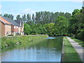
2
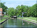
The New River east of Brookfield Lane West, EN8
Image: © Mike Quinn
Taken: 27 May 2015
0.07 miles
3
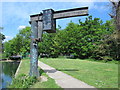
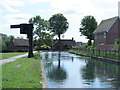
Hoist by the New River east of Brookfield Lane West, EN8
Image: © Mike Quinn
Taken: 27 May 2015
0.07 miles
4
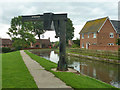
Crane by the New River
Presumably for loading and possibly launching maintenance boats. It is rated at 2 tonnes.
Image: © Robin Webster
Taken: 4 Sep 2015
0.08 miles
5
The New River east of Brookfield Lane West, EN8 (2)
Image: © Mike Quinn
Taken: 27 May 2015
0.08 miles
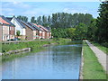
6
The New River south of Brookfield Lane West, EN8
See Image
Image: © Mike Quinn
Taken: 27 May 2015
0.08 miles
7
The New River north of Pine Close, EN8
See Image
Image: © Mike Quinn
Taken: 27 May 2015
0.08 miles
8
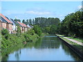
A long, straight stretch of the New River south of Brookfield Lane West, EN8
Image: © Mike Quinn
Taken: 27 May 2015
0.09 miles
9
The New River between Cheshunt Reservoir (North) and Brookfield Lane West, EN8
See Image
Image: © Mike Quinn
Taken: 27 May 2015
0.11 miles
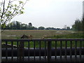
10
Field by Brookfield Lane West, Turnford
Image: © David Howard
Taken: 28 Nov 2021
0.11 miles