IMAGES TAKEN NEAR TO
Albemarle Avenue, WALTHAM CROSS, EN8 0EY
Introduction
This page details the photographs taken nearby to Albemarle Avenue, EN8 0EY by members of the Geograph project.
The Geograph project started in 2005 with the aim of publishing, organising and preserving representative images for every square kilometre of Great Britain, Ireland and the Isle of Man.

There are currently over 7.5m images from over14,400 individuals and you can help contribute to the project by visiting https://www.geograph.org.uk
Image Map
Images are licensed for reuse under creativecommons.org/licenses/by-sa/2.0
Notes
- Clicking on the map will re-center to the selected point.
- The higher the marker number, the further away the image location is from the centre of the postcode.
Image Listing (23 Images Found)
Images are licensed for reuse under creativecommons.org/licenses/by-sa/2.0
Image
Details
Distance
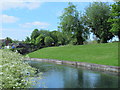
1
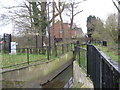
Rags Brook in Cheshunt
Rags Brook is a tributary of the River Lee or Lea and flows eastwards from near Goff's Oak to join the main river in Cheshunt. This is the view looking upstream at the flood alleviation throttle or flume structure near Cheshunt North Reservoir. When the brook has a high flow the water level rises but is squeezed through the flume until its level reaches that of an overspill lip just upstream. The excess water then flows off into the reservoir where it is stored until it can be let downstream in a controlled manner so that it does not cause flooding. The tide mark along the side of the flume indicates the level to which the brook will usually rise in a flood event before it overtops the spillway.
Image: © Nigel Cox
Taken: 18 Mar 2011
0.10 miles
2
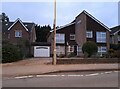
Modern house on Brookfield Road West, Flamstead End
This style was popular in the 70s, I had a flat like it once. https://www.geograph.org.uk/photo/4839443
Image: © David Howard
Taken: 28 Nov 2021
0.17 miles
3
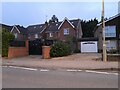
Houses on Brookfield Road West, Flamstead End
Image: © David Howard
Taken: 28 Nov 2021
0.17 miles
4
Rags Brook in Cheshunt
Rags Brook is a tributary of the River Lee or Lea and flows eastwards from near Goff's Oak to join the main river in Cheshunt. This is the view looking upstream from the Greenbank road bridge.
Image: © Nigel Cox
Taken: 18 Mar 2011
0.17 miles
5
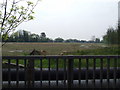
Cheshunt Reservoir South
Water shortage, what water shortage.
This is Cheshunt Reservoir South after Thames Water sold it, one of six since 2000.
Built in 1836 it apparently wasn't used despite the obvious need for it, and had become a fishing and wildlife lake.
It has now been filled in and is planned to be used for housing, which was not a popular decision locally. Of course the obvious question is - don't these extra houses need water from somewhere ?.
This picture was taken from the bridge over the New River (opened in 1613), which supplies water to London.
Image: © Talisman
Taken: 5 May 2008
0.17 miles
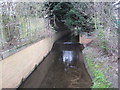
6
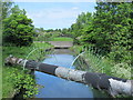
The New River between Cheshunt Reservoir (North) and Brookfield Lane West, EN8
See Image
Image: © Mike Quinn
Taken: 27 May 2015
0.18 miles
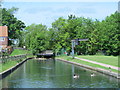
7
The New River east of Cheshunt Reservoir (North)
See Image
Image: © Mike Quinn
Taken: 27 May 2015
0.20 miles
8
The New River east of Brookfield Lane West, EN8
Image: © Mike Quinn
Taken: 27 May 2015
0.21 miles
9
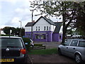
The Box
This building was completely purple until recently but they have toned it down a bit by painting the upper part white.
The Box is a hairdressing salon which sits on the corner of Halfhide Lane and Longfield Lane.
Image: © Talisman
Taken: 1 May 2008
0.22 miles
10
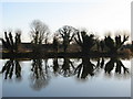
Cheshunt North Reservoir - Winter Reflections
Looking across the reservoir to the embankment dam. The willow trees have been pollarded to reduce the risk of their being blown over, which could cause damage to the embankment if they were uprooted.
The reservoir is no longer used for water supply, but is now an amenity lake, also used as flood storage during high flows in the adjacent Rags Brook to reduce the risk of flooding downstream
Image: © Andrew Pepper
Taken: 17 Dec 2008
0.22 miles