IMAGES TAKEN NEAR TO
Cain Court, Wycliffe Close, WALTHAM CROSS, EN8 0AG
Introduction
This page details the photographs taken nearby to Cain Court, Wycliffe Close, EN8 0AG by members of the Geograph project.
The Geograph project started in 2005 with the aim of publishing, organising and preserving representative images for every square kilometre of Great Britain, Ireland and the Isle of Man.

There are currently over 7.5m images from over14,400 individuals and you can help contribute to the project by visiting https://www.geograph.org.uk
Image Map
Images are licensed for reuse under creativecommons.org/licenses/by-sa/2.0
Notes
- Clicking on the map will re-center to the selected point.
- The higher the marker number, the further away the image location is from the centre of the postcode.
Image Listing (19 Images Found)
Images are licensed for reuse under creativecommons.org/licenses/by-sa/2.0
Image
Details
Distance
4
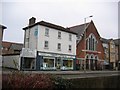
Cheshunt Free Church
Cheshunt High Street, just to the left of the photo is Fairfield House Image
Image: © Talisman
Taken: 8 Jan 2006
0.09 miles
6
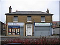
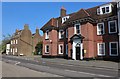
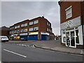
Fairfield House
Beneath the Estate Agent & Dry Cleaners is Fairfield House, Cheshunt High Street.
Around 1881 this was the home of Thomas Woollard, Watchmaker.
To the left is a nicely named alley - Kilsmore Lane
Image: © Talisman
Taken: 8 Jan 2006
0.11 miles