IMAGES TAKEN NEAR TO
Higgins Road, WALTHAM CROSS, EN7 6XS
Introduction
This page details the photographs taken nearby to Higgins Road, EN7 6XS by members of the Geograph project.
The Geograph project started in 2005 with the aim of publishing, organising and preserving representative images for every square kilometre of Great Britain, Ireland and the Isle of Man.

There are currently over 7.5m images from over14,400 individuals and you can help contribute to the project by visiting https://www.geograph.org.uk
Image Map (Loading...)


Getting Data...Please wait
Leaflet Map data © OpenStreetMap
Images are licensed for reuse under creativecommons.org/licenses/by-sa/2.0
Notes
- Clicking on the map will re-center to the selected point.
- The higher the marker number, the further away the image location is from the centre of the postcode.
Image Listing (4 Images Found)
Images are licensed for reuse under creativecommons.org/licenses/by-sa/2.0
Image
Details
Distance
1
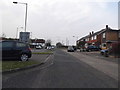
Service road by Hammondstreet Road
This is the western suburb of Cheshunt
Image: © David Howard
Taken: 28 Mar 2014
0.16 miles
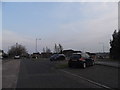
3
Hammondstret Road at the junction of Smiths Lane
Image: © David Howard
Taken: 28 Mar 2014
0.21 miles
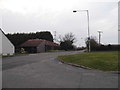
4
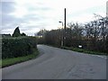
Smith Lane, Cheshunt, Hertfordshire
Smith Lane, Cheshunt, Hertfordshire, at junction with Bread and Cheese Lane and Appleby Street
Image: © Christine Matthews
Taken: 22 Jan 2006
0.25 miles