IMAGES TAKEN NEAR TO
Higgins Road, WALTHAM CROSS, EN7 6XR
Introduction
This page details the photographs taken nearby to Higgins Road, EN7 6XR by members of the Geograph project.
The Geograph project started in 2005 with the aim of publishing, organising and preserving representative images for every square kilometre of Great Britain, Ireland and the Isle of Man.

There are currently over 7.5m images from over14,400 individuals and you can help contribute to the project by visiting https://www.geograph.org.uk
Image Map
Images are licensed for reuse under creativecommons.org/licenses/by-sa/2.0
Notes
- Clicking on the map will re-center to the selected point.
- The higher the marker number, the further away the image location is from the centre of the postcode.
Image Listing (3 Images Found)
Images are licensed for reuse under creativecommons.org/licenses/by-sa/2.0
Image
Details
Distance
1
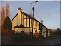
Houses in Rags Lane, Cheshunt
Attractive houses in Rags Lane, Cheshunt, Hertfordshire, opposite Burton Grange
Image: © Christine Matthews
Taken: 27 Dec 2005
0.17 miles
2
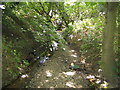
Rags Brook in Goff's Oak
Looking downstream from the Rags Lane bridge, Rags Brook is a minor tributary of the River Lee, and flows through Flamstead End and around the north side of Cheshunt.
Image: © Nigel Cox
Taken: 14 Jul 2006
0.24 miles
3
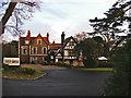
Burton Grange, Rags Lane, Cheshunt
This historic building is used as a Restaurant. There is also a nursery specialising in tropical hibiscus
Image: © Christine Matthews
Taken: 27 Dec 2005
0.24 miles