IMAGES TAKEN NEAR TO
Shambrook Road, WALTHAM CROSS, EN7 6WB
Introduction
This page details the photographs taken nearby to Shambrook Road, EN7 6WB by members of the Geograph project.
The Geograph project started in 2005 with the aim of publishing, organising and preserving representative images for every square kilometre of Great Britain, Ireland and the Isle of Man.

There are currently over 7.5m images from over14,400 individuals and you can help contribute to the project by visiting https://www.geograph.org.uk
Image Map
Images are licensed for reuse under creativecommons.org/licenses/by-sa/2.0
Notes
- Clicking on the map will re-center to the selected point.
- The higher the marker number, the further away the image location is from the centre of the postcode.
Image Listing (9 Images Found)
Images are licensed for reuse under creativecommons.org/licenses/by-sa/2.0
Image
Details
Distance
2
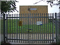
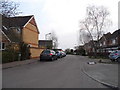
Entrance to covered reservoir site
Off Hammondstreet Road.
Image: © JThomas
Taken: 27 Jul 2019
0.16 miles
3
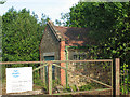
Darnicle Hill booster station
A Thames Water facility, presumably to boost the pressure on the outlet of the adjacent service reservoir to meet regulatory standards.
Image: © Stephen Craven
Taken: 4 Jun 2011
0.21 miles
4
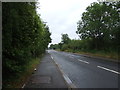
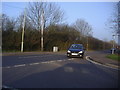
Hammondstreet Road at the junction of Newgatestreet Road
Image: © David Howard
Taken: 28 Mar 2014
0.23 miles
5
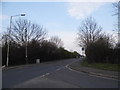
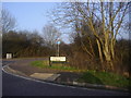
Junction of Newgatestreet Road and Hammond Street
Image: © David Howard
Taken: 2 Mar 2011
0.23 miles
7
Corner of Newgatestreet Road and Hammond Street
Image: © David Howard
Taken: 2 Mar 2011
0.24 miles
8
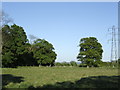
Edge of Derry's Wood
To the north-east of St. Lawrence Farm
Image: © Jonathan Billinger
Taken: 2 May 2007
0.24 miles
9
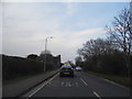
Newgatestreet Road approaching Darnicle Hill
Image: © David Howard
Taken: 28 Mar 2014
0.25 miles