IMAGES TAKEN NEAR TO
Spencer Avenue, WALTHAM CROSS, EN7 6RU
Introduction
This page details the photographs taken nearby to Spencer Avenue, EN7 6RU by members of the Geograph project.
The Geograph project started in 2005 with the aim of publishing, organising and preserving representative images for every square kilometre of Great Britain, Ireland and the Isle of Man.

There are currently over 7.5m images from over14,400 individuals and you can help contribute to the project by visiting https://www.geograph.org.uk
Image Map
Images are licensed for reuse under creativecommons.org/licenses/by-sa/2.0
Notes
- Clicking on the map will re-center to the selected point.
- The higher the marker number, the further away the image location is from the centre of the postcode.
Image Listing (13 Images Found)
Images are licensed for reuse under creativecommons.org/licenses/by-sa/2.0
Image
Details
Distance
2
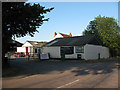
Hammond Close, Hammond Street
The town is called Hammond Street, a suburb of Cheshunt
Image: © David Howard
Taken: 28 Mar 2014
0.10 miles
3
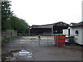
Appleby Street Farm
The farm entrance, with signs advertising produce for sale.
Image: © Stephen Craven
Taken: 4 Jun 2011
0.11 miles
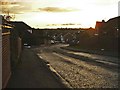
5
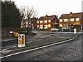
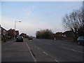
Junction of The Laurels with Hammond Street
Junction of The Laurels with Hammond Street, Cheshunt, Hertfordshire
Image: © Christine Matthews
Taken: 27 Dec 2005
0.12 miles
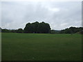
6
Children's playground on Appleby Street, Cheshunt
Image: © JThomas
Taken: 27 Jul 2019
0.13 miles
7
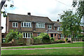
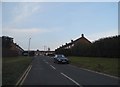
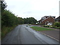
Houses on Appleby Street
On the northern edge of suburban development here.
Image: © Robin Webster
Taken: 21 Aug 2015
0.13 miles
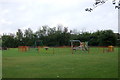
8
Recreation ground off Appleby Street, Cheshunt
Image: © JThomas
Taken: 27 Jul 2019
0.14 miles
10
The Laurels, Cheshunt, Hertfordshire
The Laurels, looking south-west
Image: © Christine Matthews
Taken: 27 Dec 2005
0.15 miles