IMAGES TAKEN NEAR TO
Longfield Lane, WALTHAM CROSS, EN7 6AQ
Introduction
This page details the photographs taken nearby to Longfield Lane, EN7 6AQ by members of the Geograph project.
The Geograph project started in 2005 with the aim of publishing, organising and preserving representative images for every square kilometre of Great Britain, Ireland and the Isle of Man.

There are currently over 7.5m images from over14,400 individuals and you can help contribute to the project by visiting https://www.geograph.org.uk
Image Map
Images are licensed for reuse under creativecommons.org/licenses/by-sa/2.0
Notes
- Clicking on the map will re-center to the selected point.
- The higher the marker number, the further away the image location is from the centre of the postcode.
Image Listing (11 Images Found)
Images are licensed for reuse under creativecommons.org/licenses/by-sa/2.0
Image
Details
Distance
1
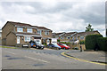
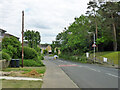
Houses on Spicersfield
In a large area of housing extending Cheshunt to the west.
Image: © Robin Webster
Taken: 24 May 2016
0.08 miles
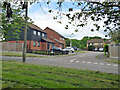
2
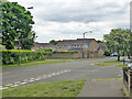
Adamsfield, Cheshunt
A distributor road in this housing development, with all houses on side roads.
Image: © Robin Webster
Taken: 24 May 2016
0.09 miles
3
Adamsfield, Cheshunt
A distributor road in this housing development, with all houses on side roads.
Image: © Robin Webster
Taken: 24 May 2016
0.17 miles
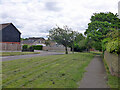
4
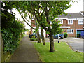
Path along Adamsfield, Cheshunt
Adamsfield is a distributor road in this housing development, with all houses on side roads.
Image: © Robin Webster
Taken: 24 May 2016
0.17 miles
6
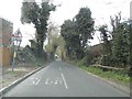
Bencroft, Cheshunt
A turning off Adamsfield.
Image: © Robin Webster
Taken: 24 May 2016
0.19 miles
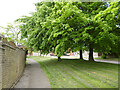
7
Path from Adamsfield to Longfield Lane, Cheshunt
Passing the end of one of the several branches of Smarts Green.
Image: © Robin Webster
Taken: 24 May 2016
0.20 miles
9
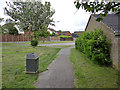
Path with dog bin, Cheshunt
The path, mostly an alley, runs the short way from the end of Smarts Green to Adamsfield. The tree is some sort of Whitebeam.
Image: © Robin Webster
Taken: 24 May 2016
0.21 miles
10
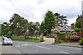
Holcroft House, Dig Dag Hill, Cheshunt
Once an isolation hospital, now flats.
Image: © Robin Webster
Taken: 24 May 2016
0.23 miles