IMAGES TAKEN NEAR TO
Darnicle Hill, WALTHAM CROSS, EN7 5TD
Introduction
This page details the photographs taken nearby to Darnicle Hill, EN7 5TD by members of the Geograph project.
The Geograph project started in 2005 with the aim of publishing, organising and preserving representative images for every square kilometre of Great Britain, Ireland and the Isle of Man.

There are currently over 7.5m images from over14,400 individuals and you can help contribute to the project by visiting https://www.geograph.org.uk
Image Map
Images are licensed for reuse under creativecommons.org/licenses/by-sa/2.0
Notes
- Clicking on the map will re-center to the selected point.
- The higher the marker number, the further away the image location is from the centre of the postcode.
Image Listing (7 Images Found)
Images are licensed for reuse under creativecommons.org/licenses/by-sa/2.0
Image
Details
Distance
1
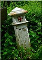
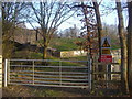
Old Boundary Marker by Darnicle Hill, Cheshunt parish
Coal Tax Marker by the UC road, in parish of Cheshunt (Broxbourne District), Darnicle Hill, East end of Newgate Street Bridge. (N.B.2018 Streetview shows top of post broken off)
Grade II listed.
List Entry Number: 1296383 https://historicengland.org.uk/listing/the-list/list-entry/1296383
To be surveyed
Milestone Society National ID: HE_CTCHE02bm
Image: © Milestone Society
Taken: Unknown
0.09 miles
2
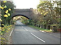
Cuffley world War 2 Anti-tank Blocks
This railway bridge at Cuffley was also an intersection with a road and a river and is protected by no less than 85 anti-tank blocks. This is the most extensive surviving group of anti-tank obstacles in Hertfordshire.
For more info visit http://www.pillboxesuk.co.uk
Image: © Ian Sanders
Taken: 4 Nov 2002
0.13 miles
5
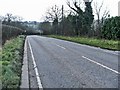
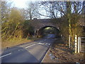
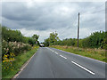
Darnicle Hill, Cheshunt, Hertfordshire
Darnicle Hill, Cheshunt, looking west.
Image: © Christine Matthews
Taken: 22 Jan 2006
0.17 miles
7
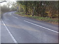
Darnicle Hill
The level bit at the top of the actual hill of 10% according to the sign.
Image: © Robin Webster
Taken: 21 Aug 2015
0.24 miles