IMAGES TAKEN NEAR TO
Goffs Lane, WALTHAM CROSS, EN7 5QQ
Introduction
This page details the photographs taken nearby to Goffs Lane, EN7 5QQ by members of the Geograph project.
The Geograph project started in 2005 with the aim of publishing, organising and preserving representative images for every square kilometre of Great Britain, Ireland and the Isle of Man.

There are currently over 7.5m images from over14,400 individuals and you can help contribute to the project by visiting https://www.geograph.org.uk
Image Map
Images are licensed for reuse under creativecommons.org/licenses/by-sa/2.0
Notes
- Clicking on the map will re-center to the selected point.
- The higher the marker number, the further away the image location is from the centre of the postcode.
Image Listing (6 Images Found)
Images are licensed for reuse under creativecommons.org/licenses/by-sa/2.0
Image
Details
Distance
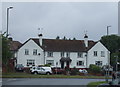
1
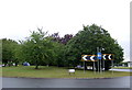
Path across the B198, Goff's Oak
Good way to bypass this busy island.
Image: © JThomas
Taken: 27 Jul 2019
0.13 miles
5
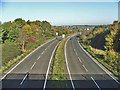
Lieutenant Ellis Way, Bury Green
Looking north from the bridge where Barrow Lane passes over the B198 Lieutenant Ellis Way, Bury Green. Are there any other B roads which are dual carriageways.
Image: © Christine Matthews
Taken: 18 Nov 2005
0.18 miles