IMAGES TAKEN NEAR TO
Burnt Farm Ride, WALTHAM CROSS, EN7 5JB
Introduction
This page details the photographs taken nearby to Burnt Farm Ride, EN7 5JB by members of the Geograph project.
The Geograph project started in 2005 with the aim of publishing, organising and preserving representative images for every square kilometre of Great Britain, Ireland and the Isle of Man.

There are currently over 7.5m images from over14,400 individuals and you can help contribute to the project by visiting https://www.geograph.org.uk
Image Map (Loading...)


Getting Data...Please wait
Leaflet Map data © OpenStreetMap
Images are licensed for reuse under creativecommons.org/licenses/by-sa/2.0
Notes
- Clicking on the map will re-center to the selected point.
- The higher the marker number, the further away the image location is from the centre of the postcode.
Image Listing (7 Images Found)
Images are licensed for reuse under creativecommons.org/licenses/by-sa/2.0
Image
Details
Distance
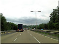
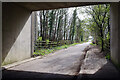
2
Burnt Farm Ride, M25 bridge
Burnt Farm Ride is a long, straight bridleway running north from Crews Hill. Here it is crossed by the M25 motorway.
Image: © Stephen Craven
Taken: 4 Jun 2011
0.10 miles
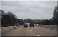
3
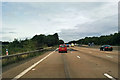
M25 heading west
The red car is just about on the bridge over Burntfarm Ride, a public bridleway and private track.
Image: © Robin Webster
Taken: 9 Jul 2016
0.10 miles
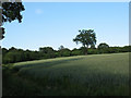
4
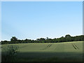
Wheatfield adjacent to Burnt Farm Ride
Wheat growing in a gently sloping field east of the Cuffley Brook.
Image: © Stephen Craven
Taken: 4 Jun 2011
0.12 miles
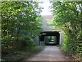
5
Burnt Farm Ride
Looking towards Crews Hill from under the M25.
Image: © Stephen McKay
Taken: 5 Apr 2023
0.15 miles
7
Solitary tree in a wheatfield
A single tree stands out within a field of wheat at Burnt Farm.
Image: © Stephen Craven
Taken: 4 Jun 2011
0.18 miles