IMAGES TAKEN NEAR TO
Carmen Crescent, EN7 5FJ
Introduction
This page details the photographs taken nearby to Carmen Crescent, EN7 5FJ by members of the Geograph project.
The Geograph project started in 2005 with the aim of publishing, organising and preserving representative images for every square kilometre of Great Britain, Ireland and the Isle of Man.

There are currently over 7.5m images from over14,400 individuals and you can help contribute to the project by visiting https://www.geograph.org.uk
Image Map (Loading...)


Getting Data...Please wait
Leaflet Map data © OpenStreetMap
Images are licensed for reuse under creativecommons.org/licenses/by-sa/2.0
Notes
- Clicking on the map will re-center to the selected point.
- The higher the marker number, the further away the image location is from the centre of the postcode.
Image Listing (7 Images Found)
Images are licensed for reuse under creativecommons.org/licenses/by-sa/2.0
Image
Details
Distance
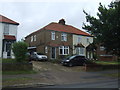
1
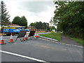
Halstead Hill meets Goff's Lane
The road is signed as closed here, but entering from the other end it proved to be possible to drive right through.
Image: © Robin Webster
Taken: 21 Aug 2015
0.13 miles
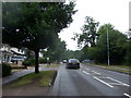
2
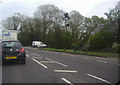
Goffs Lane at the junction of Halstead Hill
The traffic is waiting to get on the roundabout ahead.
Image: © David Howard
Taken: 2 May 2012
0.14 miles
4
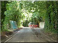
Road works on Halstead Hill
The road was signed as closed, but it was possible to get through - probably a recent tidying up.
Image: © Robin Webster
Taken: 21 Aug 2015
0.18 miles
7
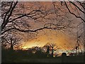
Farmland off Andrews Lane, Cheshunt, Hertfordshire
Late afternoon shot showing the setting sun through the woods.
Image: © Christine Matthews
Taken: 27 Dec 2005
0.25 miles