IMAGES TAKEN NEAR TO
Cucino Way, EN7 5FG
Introduction
This page details the photographs taken nearby to Cucino Way, EN7 5FG by members of the Geograph project.
The Geograph project started in 2005 with the aim of publishing, organising and preserving representative images for every square kilometre of Great Britain, Ireland and the Isle of Man.

There are currently over 7.5m images from over14,400 individuals and you can help contribute to the project by visiting https://www.geograph.org.uk
Image Map
Images are licensed for reuse under creativecommons.org/licenses/by-sa/2.0
Notes
- Clicking on the map will re-center to the selected point.
- The higher the marker number, the further away the image location is from the centre of the postcode.
Image Listing (7 Images Found)
Images are licensed for reuse under creativecommons.org/licenses/by-sa/2.0
Image
Details
Distance
1
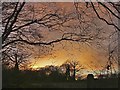
Farmland off Andrews Lane, Cheshunt, Hertfordshire
Late afternoon shot showing the setting sun through the woods.
Image: © Christine Matthews
Taken: 27 Dec 2005
0.10 miles
2
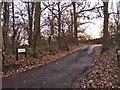
Lea Mount, off Andrews Lane, Cheshunt
Lea Mount is a track leading southwards off Andrews Lane, Cheshunt, Hertfordshire
Image: © Christine Matthews
Taken: 27 Dec 2005
0.15 miles
3

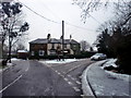
Garden, Prince of Wales Public House, Goffs Oak, Hertfordshire
Image: © Christine Matthews
Taken: 15 Aug 2010
0.18 miles
4
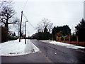
St James Road, Goffs Oak
Looking towards the junction of St James Road with Burton Lane/Rags Lane.
Image: © Christine Matthews
Taken: 14 Jan 2010
0.18 miles
5
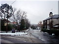
St James Road, Goffs Oak
Looking along St James Road from the corner of the junction with Burton Lane.
Image: © Christine Matthews
Taken: 14 Jan 2010
0.20 miles
6
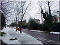
St James Road, Goffs Oak
St James Road as seen from the car park entrance to the Prince of Wales public house.
Image: © Christine Matthews
Taken: 14 Jan 2010
0.21 miles
7
Rags Lane, Goffs Oak
Looking along Rags Lane from the corner of St James Road.
Image: © Christine Matthews
Taken: 14 Jan 2010
0.23 miles