IMAGES TAKEN NEAR TO
Franklin Avenue, WALTHAM CROSS, EN7 5EA
Introduction
This page details the photographs taken nearby to Franklin Avenue, EN7 5EA by members of the Geograph project.
The Geograph project started in 2005 with the aim of publishing, organising and preserving representative images for every square kilometre of Great Britain, Ireland and the Isle of Man.

There are currently over 7.5m images from over14,400 individuals and you can help contribute to the project by visiting https://www.geograph.org.uk
Image Map
Images are licensed for reuse under creativecommons.org/licenses/by-sa/2.0
Notes
- Clicking on the map will re-center to the selected point.
- The higher the marker number, the further away the image location is from the centre of the postcode.
Image Listing (28 Images Found)
Images are licensed for reuse under creativecommons.org/licenses/by-sa/2.0
Image
Details
Distance

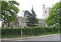
4
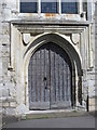
St. Mary's Church, Churchgate, EN8 - west door
Image: © Mike Quinn
Taken: 30 Jul 2014
0.21 miles
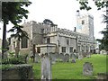
5
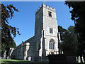
St. Mary's Church, Churchgate, EN8 - tower and north side
See also Image
Image: © Mike Quinn
Taken: 30 Jul 2014
0.21 miles
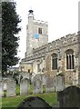
6
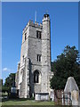
St. Mary's Church, Churchgate, EN8 - tower
Shows the stair turret at the southeast corner of the tower. See also Image
Image: © Mike Quinn
Taken: 30 Jul 2014
0.21 miles
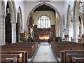
7
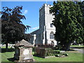
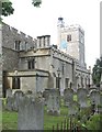
St. Mary's Church and churchyard, Churchgate, EN8
Image: © Mike Quinn
Taken: 30 Jul 2014
0.21 miles