IMAGES TAKEN NEAR TO
Cromwell Avenue, WALTHAM CROSS, EN7 5DN
Introduction
This page details the photographs taken nearby to Cromwell Avenue, EN7 5DN by members of the Geograph project.
The Geograph project started in 2005 with the aim of publishing, organising and preserving representative images for every square kilometre of Great Britain, Ireland and the Isle of Man.

There are currently over 7.5m images from over14,400 individuals and you can help contribute to the project by visiting https://www.geograph.org.uk
Image Map
Images are licensed for reuse under creativecommons.org/licenses/by-sa/2.0
Notes
- Clicking on the map will re-center to the selected point.
- The higher the marker number, the further away the image location is from the centre of the postcode.
Image Listing (65 Images Found)
Images are licensed for reuse under creativecommons.org/licenses/by-sa/2.0
Image
Details
Distance
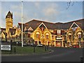
2
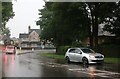
Broxbourne Council offices, Churchgate, EN8
Image: © Mike Quinn
Taken: 30 Jul 2014
0.13 miles
3
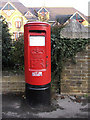
Elizabeth II Pillar Box, outside Broxbourne Civic Offices
This pillar box is situated outside the Broxbourne Civic Offices, which can be seen in the background to this image.
Image: © Christine Matthews
Taken: 27 Dec 2005
0.13 miles
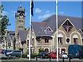
4
Cheshunt : Broxbourne Council Offices
Tower of the former Cheshunt College, architects Lander & Bedells. See also Image
Image: © Jim Osley
Taken: 6 Aug 2020
0.13 miles
5
Broxbourne Borough Offices, Churchgate, Cheshunt, Hertfordshire
Image: © Christine Matthews
Taken: 27 Dec 2005
0.14 miles
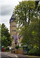
6
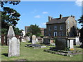
St. Mary's Church, Churchgate, EN8 - churchyard
See Image
Image: © Mike Quinn
Taken: 30 Jul 2014
0.14 miles
7
St. Mary's Church, Churchgate, EN8 - churchyard (2)
See Image
Image: © Mike Quinn
Taken: 30 Jul 2014
0.14 miles
8
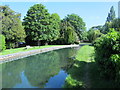
The New River north of College Road, EN8 (2)
In the grounds of the offices of Broxbourne Council.
The New River is neither new (having been built at the beginning of the 17th C) nor a river (it's an aqueduct supplying water to London, taken from the River Lea near Hertford and from Chadwell Spring, Amwell Spring, and other springs and wells along its course). For further info, see the Wiki entry http://en.wikipedia.org/wiki/New_River_(England) .
Image: © Mike Quinn
Taken: 27 May 2015
0.14 miles
9
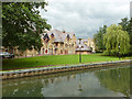
Broxbourne Borough offices
Seen across the New River.
Image: © Robin Webster
Taken: 4 Sep 2015
0.14 miles
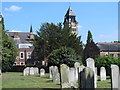
10
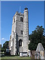
St. Mary's Church, Churchgate, EN8 - tower
Shows the stair turret at the southeast corner of the tower. See also Image
Image: © Mike Quinn
Taken: 30 Jul 2014
0.15 miles