IMAGES TAKEN NEAR TO
Tudor Avenue, WALTHAM CROSS, EN7 5AZ
Introduction
This page details the photographs taken nearby to Tudor Avenue, EN7 5AZ by members of the Geograph project.
The Geograph project started in 2005 with the aim of publishing, organising and preserving representative images for every square kilometre of Great Britain, Ireland and the Isle of Man.

There are currently over 7.5m images from over14,400 individuals and you can help contribute to the project by visiting https://www.geograph.org.uk
Image Map
Images are licensed for reuse under creativecommons.org/licenses/by-sa/2.0
Notes
- Clicking on the map will re-center to the selected point.
- The higher the marker number, the further away the image location is from the centre of the postcode.
Image Listing (17 Images Found)
Images are licensed for reuse under creativecommons.org/licenses/by-sa/2.0
Image
Details
Distance
5
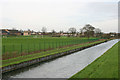
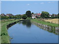
St Mary's CofE High School, Cheshunt
Seen from the New River. The school relocated to this site in 2010 from elsewhere in the town and is therefore not shown on all OS maps.
Image: © David Kemp
Taken: 19 Dec 2015
0.16 miles
6
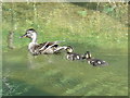
Mallard and chicks in the New River at Bury Green
See Image
Image: © Mike Quinn
Taken: 30 Jul 2014
0.18 miles
7
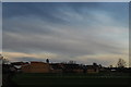
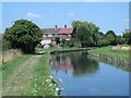
St Mary's School, Cheshunt
Shot from the footbridge over the New River.
Image: © John Winder
Taken: 9 Jan 2015
0.18 miles
8
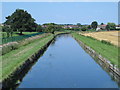
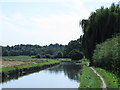
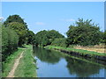
The New River east of Broom Hills
Image: © Mike Quinn
Taken: 30 Jul 2014
0.19 miles
10
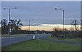
Lieutenant Ellis Way looking East towards the A10
Lieutenant Ellis Way, B198, looking eastwards towards the junction with the A10, Cambridge Road.
Image: © Christine Matthews
Taken: 18 Dec 2005
0.20 miles