IMAGES TAKEN NEAR TO
Bullsmoor Lane, ENFIELD, EN1 4SA
Introduction
This page details the photographs taken nearby to Bullsmoor Lane, EN1 4SA by members of the Geograph project.
The Geograph project started in 2005 with the aim of publishing, organising and preserving representative images for every square kilometre of Great Britain, Ireland and the Isle of Man.

There are currently over 7.5m images from over14,400 individuals and you can help contribute to the project by visiting https://www.geograph.org.uk
Image Map (Loading...)


Getting Data...Please wait
Leaflet Map data © OpenStreetMap
Images are licensed for reuse under creativecommons.org/licenses/by-sa/2.0
Notes
- Clicking on the map will re-center to the selected point.
- The higher the marker number, the further away the image location is from the centre of the postcode.
Image Listing (31 Images Found)
Images are licensed for reuse under creativecommons.org/licenses/by-sa/2.0
Image
Details
Distance
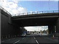
2
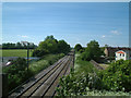
Bullsmore Lane bridge over railway
The railway is the mainline from London Liverpool Street to Cambridge. To the left is a playground and playing fields; to the right is a residential care home and local housing.
Image: © Stephen Dawson
Taken: 15 May 2005
0.05 miles
3
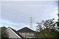
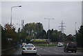
Pylon and offices by Bullsmoor Lane, Freezywater
Image: © David Howard
Taken: 10 Jan 2012
0.11 miles
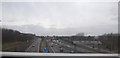
9
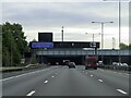
The M25 entering the Holmesdale Tunnel
Image: © Steve Daniels
Taken: 10 Oct 2020
0.16 miles
10
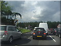
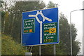
The A10 approaching the M25, Cheshunt
Image: © David Howard
Taken: 13 Jun 2012
0.16 miles