IMAGES TAKEN NEAR TO
Copse Close, EN1 4DW
Introduction
This page details the photographs taken nearby to Copse Close, EN1 4DW by members of the Geograph project.
The Geograph project started in 2005 with the aim of publishing, organising and preserving representative images for every square kilometre of Great Britain, Ireland and the Isle of Man.

There are currently over 7.5m images from over14,400 individuals and you can help contribute to the project by visiting https://www.geograph.org.uk
Image Map (Loading...)


Getting Data...Please wait
Leaflet Map data © OpenStreetMap
Images are licensed for reuse under creativecommons.org/licenses/by-sa/2.0
Notes
- Clicking on the map will re-center to the selected point.
- The higher the marker number, the further away the image location is from the centre of the postcode.
Image Listing (77 Images Found)
Images are licensed for reuse under creativecommons.org/licenses/by-sa/2.0
Image
Details
Distance
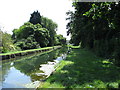
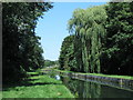
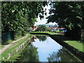
3
The New River north of Bullsmoor Lane (3)
Image: © Mike Quinn
Taken: 30 Jul 2014
0.06 miles
4
The New River between Bullsmoor Lane and the M25 (2)
See Image
Image: © Mike Quinn
Taken: 30 Jul 2014
0.06 miles
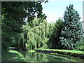
5
The New River between Bullsmoor Lane and the M25
See Image
Image: © Mike Quinn
Taken: 30 Jul 2014
0.06 miles
6
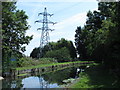
The New River and pylon south of the M25
See Image
Image: © Mike Quinn
Taken: 30 Jul 2014
0.07 miles
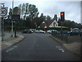
8
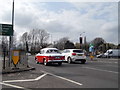
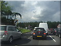
Hillman Minx at the A10 crossroads, Waltham Cross
Image: © David Howard
Taken: 7 Apr 2018
0.08 miles
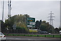
10
Bullsmoor Lane
The split junction from the A10
Image: © David Howard
Taken: 20 Sep 2011
0.09 miles