IMAGES TAKEN NEAR TO
Stanstead Drive, HODDESDON, EN11 9HQ
Introduction
This page details the photographs taken nearby to Stanstead Drive, EN11 9HQ by members of the Geograph project.
The Geograph project started in 2005 with the aim of publishing, organising and preserving representative images for every square kilometre of Great Britain, Ireland and the Isle of Man.

There are currently over 7.5m images from over14,400 individuals and you can help contribute to the project by visiting https://www.geograph.org.uk
Image Map
Images are licensed for reuse under creativecommons.org/licenses/by-sa/2.0
Notes
- Clicking on the map will re-center to the selected point.
- The higher the marker number, the further away the image location is from the centre of the postcode.
Image Listing (7 Images Found)
Images are licensed for reuse under creativecommons.org/licenses/by-sa/2.0
Image
Details
Distance
2
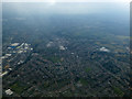
Hoddesdon from the air
Looking south over the north end of the town.
Image: © Thomas Nugent
Taken: 16 Mar 2016
0.20 miles
3
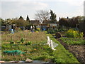
Stanstead Road Allotments Plot 41 2007
This is how we found our plot in April.
By the end of the year we had reaped fruit,veg and salads.
Image: © Vicki Pluckrose
Taken: 4 Apr 2007
0.21 miles