IMAGES TAKEN NEAR TO
Brocket Road, HODDESDON, EN11 8PF
Introduction
This page details the photographs taken nearby to Brocket Road, EN11 8PF by members of the Geograph project.
The Geograph project started in 2005 with the aim of publishing, organising and preserving representative images for every square kilometre of Great Britain, Ireland and the Isle of Man.

There are currently over 7.5m images from over14,400 individuals and you can help contribute to the project by visiting https://www.geograph.org.uk
Image Map
Images are licensed for reuse under creativecommons.org/licenses/by-sa/2.0
Notes
- Clicking on the map will re-center to the selected point.
- The higher the marker number, the further away the image location is from the centre of the postcode.
Image Listing (54 Images Found)
Images are licensed for reuse under creativecommons.org/licenses/by-sa/2.0
Image
Details
Distance
3
Houses in Rose Vale, Hoddesdon
At the north end of Rose Vale, where it meets Lord Street. On the end house, a terracotta panel at first-floor level gives the name 'Bombay Cottage', with the date 1895. Terracotta panels at second-floor level give the rather grand names of the other two houses: Chatsworth and Claremont.
Image: © Stefan Czapski
Taken: 7 Jun 2014
0.09 miles
4
Rose Vale at the junction of Lord Street
Image: © David Howard
Taken: 2 Dec 2017
0.10 miles
5
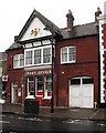
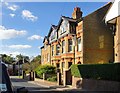
Hoddesdon Post Office
Built 1893 to the designs of John Allen Tregelles. Locally listed.
Image: © Jim Osley
Taken: 19 Oct 2012
0.12 miles
6
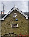
West End Terrace, Lord Street: name and date
The name of this terrace of eight cottages (along with date of building, 1884) , shown on the central gable, facing the street.
For a general view of the terrace see: http://www.geograph.org.uk/photo/4063012
Image: © Stefan Czapski
Taken: 6 Jul 2014
0.13 miles
7
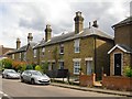
West End Terrace, Lord Street
A terrace of eight cottages. The name is given on the central gable, along with the date, 1884: http://www.geograph.org.uk/photo/4063024 All the lintels appear to be of Coade stone, a material more typical of the earlier years of the 19th century. No original front-doors seem to have survived, and there has been some piece-meal renewal of windows - but the original window sizes and shapes have been respected, so the terrace still gives the impression of being a unit.
Image: © Stefan Czapski
Taken: 6 Jul 2014
0.13 miles
8
Conduit Lane in Hoddesdon
The building on the far right is the town's main Post Office.
Image: © Robert Edwards
Taken: 9 Sep 2009
0.13 miles
10
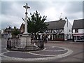
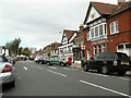
Hoddesdon Town
Hoddesdon Town Centre showing War Memorial and White Swan Public House
Image: © Chris Hunt
Taken: 3 Jul 2005
0.13 miles