IMAGES TAKEN NEAR TO
North Road, HODDESDON, EN11 8JQ
Introduction
This page details the photographs taken nearby to North Road, EN11 8JQ by members of the Geograph project.
The Geograph project started in 2005 with the aim of publishing, organising and preserving representative images for every square kilometre of Great Britain, Ireland and the Isle of Man.

There are currently over 7.5m images from over14,400 individuals and you can help contribute to the project by visiting https://www.geograph.org.uk
Image Map
Images are licensed for reuse under creativecommons.org/licenses/by-sa/2.0
Notes
- Clicking on the map will re-center to the selected point.
- The higher the marker number, the further away the image location is from the centre of the postcode.
Image Listing (48 Images Found)
Images are licensed for reuse under creativecommons.org/licenses/by-sa/2.0
Image
Details
Distance
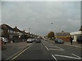
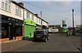
1
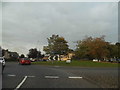
Roundabout on Amwell Street, Hoddesdon
Image: © David Howard
Taken: 15 Oct 2015
0.07 miles
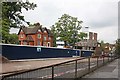
3
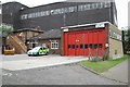
Hoddesdon fire station
Hoddesdon fire station, Burford Street, Hoddesdon, Hertfordshire
Image: © Kevin Hale
Taken: 6 Oct 2007
0.10 miles
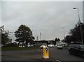
4
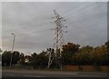
Pylon by Dinant Link Road, Hoddesdon
However long you drive along this road it can never take you to Dinant, only Ware.
Image: © David Howard
Taken: 15 Oct 2015
0.12 miles
7
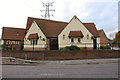
The Sun, Public House, Hoddesdon
This Mc Mullan pub was built on the same site as the old pub of the same name.
Image: © Melvyn Cousins
Taken: 24 Nov 2006
0.14 miles
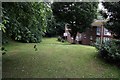
10
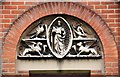
St Catherine & St Paul, Hoddesdon - Tympanum
Image: © John Salmon
Taken: 10 Jun 2009
0.16 miles