IMAGES TAKEN NEAR TO
High Street, HODDESDON, EN11 8HL
Introduction
This page details the photographs taken nearby to High Street, EN11 8HL by members of the Geograph project.
The Geograph project started in 2005 with the aim of publishing, organising and preserving representative images for every square kilometre of Great Britain, Ireland and the Isle of Man.

There are currently over 7.5m images from over14,400 individuals and you can help contribute to the project by visiting https://www.geograph.org.uk
Image Map
Images are licensed for reuse under creativecommons.org/licenses/by-sa/2.0
Notes
- Clicking on the map will re-center to the selected point.
- The higher the marker number, the further away the image location is from the centre of the postcode.
Image Listing (52 Images Found)
Images are licensed for reuse under creativecommons.org/licenses/by-sa/2.0
Image
Details
Distance
6
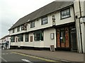
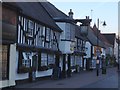
'The Bell' inn, Burford Street, Hoddesdon
This building dates back to the 16th century.
Image: © Robert Edwards
Taken: 9 Sep 2009
0.05 miles
9
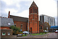
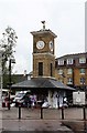
St Catherine & St Paul Church
Behind, are the Tower Precinct flats, which tower over the church.
Image: © Melvyn Cousins
Taken: 24 Nov 2006
0.08 miles
10
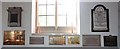
St Catherine & St Paul, Hoddesdon, Herts - Wall memorials
Image: © John Salmon
Taken: 15 Jun 2009
0.08 miles