IMAGES TAKEN NEAR TO
High Street, HODDESDON, EN11 8BH
Introduction
This page details the photographs taken nearby to High Street, EN11 8BH by members of the Geograph project.
The Geograph project started in 2005 with the aim of publishing, organising and preserving representative images for every square kilometre of Great Britain, Ireland and the Isle of Man.

There are currently over 7.5m images from over14,400 individuals and you can help contribute to the project by visiting https://www.geograph.org.uk
Image Map (Loading...)


Getting Data...Please wait
Leaflet Map data © OpenStreetMap
Images are licensed for reuse under creativecommons.org/licenses/by-sa/2.0
Notes
- Clicking on the map will re-center to the selected point.
- The higher the marker number, the further away the image location is from the centre of the postcode.
Image Listing (42 Images Found)
Images are licensed for reuse under creativecommons.org/licenses/by-sa/2.0
Image
Details
Distance
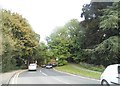
1
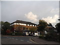
The Knowle at the junction of Cock Lane
Image: © David Howard
Taken: 15 Oct 2015
0.10 miles

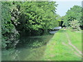
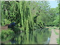
4
The New River, Spitalbrook
Viewed looking upstream from the Upper Marsh Lane road bridge, with a couple of coots lower left. See Image for a description of the aqueduct.
Image: © Nigel Cox
Taken: 5 Jan 2007
0.16 miles
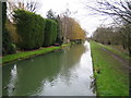
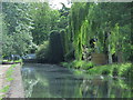
5
The New River south of Upper Marsh Lane, EN11
See Image
Image: © Mike Quinn
Taken: 27 May 2015
0.16 miles
6
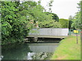
Bridge over the New River at Upper Marsh Lane, EN11
See Image
Image: © Mike Quinn
Taken: 27 May 2015
0.17 miles
7
The New River east of Yewlands, EN11 (2)
See Image
Image: © Mike Quinn
Taken: 27 May 2015
0.17 miles
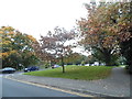
10
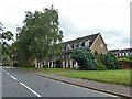
Houses on Park View
The park is indeed across the road, but the view will be obscured by those birches.
Image: © Robin Webster
Taken: 21 Aug 2015
0.17 miles