IMAGES TAKEN NEAR TO
Stanstead Road, HODDESDON, EN11 0QG
Introduction
This page details the photographs taken nearby to Stanstead Road, EN11 0QG by members of the Geograph project.
The Geograph project started in 2005 with the aim of publishing, organising and preserving representative images for every square kilometre of Great Britain, Ireland and the Isle of Man.

There are currently over 7.5m images from over14,400 individuals and you can help contribute to the project by visiting https://www.geograph.org.uk
Image Map (Loading...)


Getting Data...Please wait
Leaflet Map data © OpenStreetMap
Images are licensed for reuse under creativecommons.org/licenses/by-sa/2.0
Notes
- Clicking on the map will re-center to the selected point.
- The higher the marker number, the further away the image location is from the centre of the postcode.
Image Listing (24 Images Found)
Images are licensed for reuse under creativecommons.org/licenses/by-sa/2.0
Image
Details
Distance

2
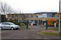
John Warner School
When built in 1953 it was called The Hoddesdon Secondary School, but was changed to its present name in 1968 in honour of John Warner a local quaker, born in 1776.
Image: © Melvyn Cousins
Taken: 24 Nov 2006
0.10 miles
3
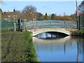
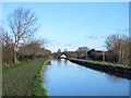
The Cranbourne Drive bridge over the New River
See Image
Image: © Mike Quinn
Taken: 14 Jan 2015
0.12 miles
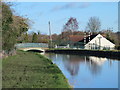
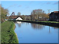
4
The New River north of Field Way, EN11 (3)
Image: © Mike Quinn
Taken: 14 Jan 2015
0.12 miles
5
The New River just south of Cranbourne Drive, EN11
See Image
Image: © Mike Quinn
Taken: 14 Jan 2015
0.12 miles
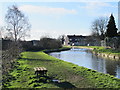
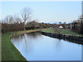
6
The New River south of Cranbourne Drive, EN11
See Image
Image: © Mike Quinn
Taken: 14 Jan 2015
0.12 miles
7
The New River south of Cranbourne Drive, EN11 (2)
See Image
Image: © Mike Quinn
Taken: 14 Jan 2015
0.13 miles
9
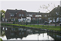
Houses beside New River, Hoddesdon
The houses in question are situated in Field Way.
Image: © David Kemp
Taken: 27 Oct 2015
0.13 miles
10
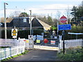
Cranbourne Level Crossing
On the Hertford East branch line between Rye House and St. Margaret's.
Image: © Mike Quinn
Taken: 14 Jan 2015
0.15 miles