IMAGES TAKEN NEAR TO
Farm Lane, HODDESDON, EN11 0HD
Introduction
This page details the photographs taken nearby to Farm Lane, EN11 0HD by members of the Geograph project.
The Geograph project started in 2005 with the aim of publishing, organising and preserving representative images for every square kilometre of Great Britain, Ireland and the Isle of Man.

There are currently over 7.5m images from over14,400 individuals and you can help contribute to the project by visiting https://www.geograph.org.uk
Image Map (Loading...)


Getting Data...Please wait
Leaflet Map data © OpenStreetMap
Images are licensed for reuse under creativecommons.org/licenses/by-sa/2.0
Notes
- Clicking on the map will re-center to the selected point.
- The higher the marker number, the further away the image location is from the centre of the postcode.
Image Listing (61 Images Found)
Images are licensed for reuse under creativecommons.org/licenses/by-sa/2.0
Image
Details
Distance
3
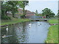
The New River southeast of Salisbury Road, EN11 (2)
See Image
Image: © Mike Quinn
Taken: 27 May 2015
0.04 miles
4
The New River southeast of Stortford Road, EN11 (3)
See Image
Image: © Mike Quinn
Taken: 27 May 2015
0.04 miles
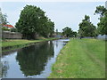
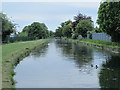
5
The New River south of Farm Lane, EN11
See Image
Image: © Mike Quinn
Taken: 27 May 2015
0.04 miles
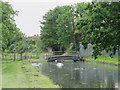
6
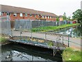
Footbridge over the New River at Farm Lane, EN11
See Image
Image: © Mike Quinn
Taken: 27 May 2015
0.04 miles
8
Tufty ducks in the New River southeast of Salisbury Road, EN11
See Image
Image: © Mike Quinn
Taken: 27 May 2015
0.04 miles
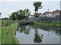
10
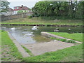
Slipway on the New River south of Farm Lane, EN11
See Image
Image: © Mike Quinn
Taken: 27 May 2015
0.06 miles